Būgai geodata
Būgai (Tauragė County) is a populated place; located in Lithuania in Europe/Vilnius (GMT+3) time zone. With population of 1,976 people, there are 95 cities with bigger population in this country. Compared to other cities in Lithuania, 62.7% of cities are located further ↓South; 80.6% of cities are located further →East and 62.7% of cities have lower elevation than Būgai. Note1


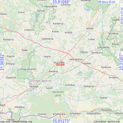
Būgai GPS coordinates[2]
55° 24' 49.932" North, 22° 36' 32.184" East
| Map corner | latitude | longitude |
|---|---|---|
| Upper-left | 55.81098°, | 21.90582° |
| Center: | 55.41387°, | 22.60894° |
| Lower-right: | 55.01273°, | 23.31207° |
| Map W x H: | 88.8×88.8 km | = 55.2×55.2mi |
| max Lat: | 56.36149° ⇑37.3% North |
| Būgai: | 55.41387° |
| min Lat: | ⇓62.7% South 54.01573° |
| min Long | Būgai | max Long |
| 20.99651° | 22.60894° | 26.43984° |
| W 19.4%⇐ | ⇒80.6% E |
Elevation
Elevation of Būgai is 106 m = 348 ft, and this is 15.3 m = 50 ft above average elevation for this country.
| Max E: |
204 m = 669 ft | 37.3% |
| Būgai | 106 m 348 ft | |
| Avg. | 90.7 m = 298 ft | |
Min E: |
-1 m = -3 ft | 62.7% |
See also: Lithuania elevation on elevation.city.
Geographical zone
Būgai is located in North temperate zone (between Tropic of Cancer and the Arctic Circle). Distance of this North polar circle is 1239.7 km =770.3 mi to North.| Distance of | km | miles | from Būgai |
|---|---|---|---|
| North Pole | 3845.6 | 2389.5 | to North |
| Arctic Circle | 1239.7 | 770.3 | to North |
| Tropic Cancer | 3555.5 | 2209.3 | to South |
| Equator | 6161.4 | 3828.5 | to South |


Nearby cities:
15 places around Būgai: (largest is in red/bold)
• Ariogala
57.4 km =35.7 mi,  107°
107°
• Gelgaudiškis
44.1 km =27.4 mi,  148°
148°
• Jurbarkas
38.9 km =24.2 mi,  165°
165°
• Kelmė
31.6 km =19.6 mi,  40°
40°
• Pagėgiai
53.7 km =33.4 mi,  235°
235°
• Raseiniai
32.7 km =20.3 mi,  96°
96°
• Rietavas
55.4 km =34.4 mi,  308°
308°
• Smalininkai
37.6 km =23.4 mi,  182°
182°
• Taurage
27 km =16.8 mi,  228°
228°
• Tytuvėnėliai
42.4 km =26.3 mi,  56°
56°
• Užventis
41.1 km =25.5 mi,  3°
3°
• Varniai
39.6 km =24.6 mi,  337°
337°
• Šakiai
58.3 km =36.2 mi, 151°
• Šilalė
27.9 km =17.3 mi,  287°
287°
• Žemaičių Naumiestis
57.5 km =35.7 mi,  263°
263°
Sources, notices
• [Note1] Compared only with cities in Lithuania existing in our database
• [Src1] Map data: © OpenStreetMap contributors (CC-BY-SA)
• [Src2] Other city data from geonames.org with taken over terms of usage.
• [Src3] Geographical zone / Annual Mean Temperature by Robert A. Rohde @ Wikipedia
