Taurage geodata
Taurage (Tauragė County) is a seat of a first-order administrative division; located in Lithuania in Europe/Vilnius (GMT+3) time zone. With population of 27,662 people, there are 20 cities with bigger population in this country. Compared to other cities in Lithuania, 54.5% of cities are located further ↓South; 84.3% of cities are located further →East and 85.8% of cities have higher elevation than Taurage. Note1


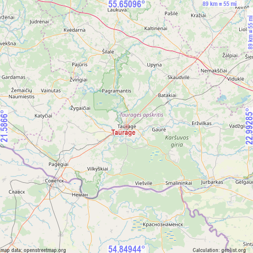
Taurage GPS coordinates[2]
55° 15' 7.992" North, 22° 17' 22.992" East
| Map corner | latitude | longitude |
|---|---|---|
| Upper-left | 55.65096°, | 21.5866° |
| Center: | 55.25222°, | 22.28972° |
| Lower-right: | 54.84944°, | 22.99285° |
| Map W x H: | 89.1×89.1 km | = 55.4×55.4mi |
| max Lat: | 56.36149° ⇑45.5% North |
| Taurage: | 55.25222° |
| min Lat: | ⇓54.5% South 54.01573° |
| min Long | Taurage | max Long |
| 20.99651° | 22.28972° | 26.43984° |
| W 15.7%⇐ | ⇒84.3% E |
Elevation
Elevation of Taurage is 36 m = 118 ft, and this is 54.7 m = 179 ft below average elevation for this country.
| Max E: |
204 m = 669 ft | 85.8% |
| Avg. | 90.7 m = 298 ft | |
| Taurage | 36 m = 118 ft | |
Min E: |
-1 m = -3 ft | 14.2% |
See also: Lithuania elevation on elevation.city.
Geographical zone
Taurage is located in North temperate zone (between Tropic of Cancer and the Arctic Circle). Distance of this North polar circle is 1257.7 km =781.5 mi to North.| Distance of | km | miles | from Taurage |
|---|---|---|---|
| North Pole | 3863.6 | 2400.7 | to North |
| Arctic Circle | 1257.7 | 781.5 | to North |
| Tropic Cancer | 3537.6 | 2198.2 | to South |
| Equator | 6143.5 | 3817.4 | to South |


Nearby cities:
15 places around Taurage: (largest is in red/bold)
• Būgai
27 km =16.8 mi,  48°
48°
• Gelgaudiškis
47.8 km =29.7 mi,  114°
114°
• Jurbarkas
36 km =22.4 mi,  123°
123°
• Kelmė
58.5 km =36.4 mi,  44°
44°
• Pagėgiai
27 km =16.8 mi,  241°
241°
• Raseiniai
54.6 km =33.9 mi,  74°
74°
• Rietavas
57.6 km =35.8 mi,  336°
336°
• Rusnė
58.4 km =36.3 mi,  275°
275°
• Silute
52.2 km =32.4 mi, 281°
• Smalininkai
27.1 km =16.8 mi,  136°
136°
• Užventis
63.2 km =39.3 mi,  21°
21°
• Varniai
55 km =34.2 mi,  5°
5°
• Šakiai
58.6 km =36.4 mi, 124°
• Šilalė
27.2 km =16.9 mi,  346°
346°
• Žemaičių Naumiestis
39 km =24.2 mi,  287°
287°
In other languages:
- In Spanish: Tauragė
- In France: Tauragė
- In German: Tauroggen, Tauragė
- In Russian: Таураге
- In Chinese: 陶拉格
Sources, notices
• [Note1] Compared only with cities in Lithuania existing in our database
• [Src1] Map data: © OpenStreetMap contributors (CC-BY-SA)
• [Src2] Other city data from geonames.org with taken over terms of usage.
• [Src3] Geographical zone / Annual Mean Temperature by Robert A. Rohde @ Wikipedia
