Raseiniai geodata
Raseiniai (Kaunas) is a seat of a second-order administrative division; located in Lithuania in Europe/Vilnius (GMT+3) time zone. With population of 12,523 people, there are 41 cities with bigger population in this country. Compared to other cities in Lithuania, 61.9% of cities are located further ↓South; 70.1% of cities are located further →East and 55.2% of cities have lower elevation than Raseiniai. Note1


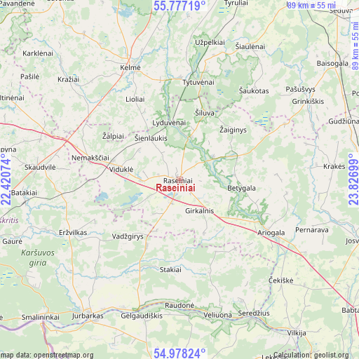
Raseiniai GPS coordinates[2]
55° 22' 47.028" North, 23° 7' 25.896" East
| Map corner | latitude | longitude |
|---|---|---|
| Upper-left | 55.77719°, | 22.42074° |
| Center: | 55.37973°, | 23.12386° |
| Lower-right: | 54.97824°, | 23.82699° |
| Map W x H: | 88.8×88.8 km | = 55.2×55.2mi |
| max Lat: | 56.36149° ⇑38.1% North |
| Raseiniai: | 55.37973° |
| min Lat: | ⇓61.9% South 54.01573° |
| min Long | Raseiniai | max Long |
| 20.99651° | 23.12386° | 26.43984° |
| W 29.9%⇐ | ⇒70.1% E |
Elevation
Elevation of Raseiniai is 93 m = 305 ft, and this is 2.3 m = 8 ft above average elevation for this country.
| Max E: |
204 m = 669 ft | 44.8% |
| Raseiniai | 93 m 305 ft | |
| Avg. | 90.7 m = 298 ft | |
Min E: |
-1 m = -3 ft | 55.2% |
See also: Lithuania elevation on elevation.city.
Geographical zone
Raseiniai is located in North temperate zone (between Tropic of Cancer and the Arctic Circle). Distance of this North polar circle is 1243.5 km =772.7 mi to North.| Distance of | km | miles | from Raseiniai |
|---|---|---|---|
| North Pole | 3849.4 | 2391.9 | to North |
| Arctic Circle | 1243.5 | 772.7 | to North |
| Tropic Cancer | 3551.7 | 2206.9 | to South |
| Equator | 6157.6 | 3826.2 | to South |


Nearby cities:
15 places around Raseiniai: (largest is in red/bold)
• Ariogala
25.9 km =16.1 mi,  120°
120°
• Būgai
32.7 km =20.3 mi,  276°
276°
• Dotnuva
48 km =29.8 mi,  91°
91°
• Gelgaudiškis
34.9 km =21.7 mi,  195°
195°
• Jurbarkas
40.8 km =25.4 mi,  213°
213°
• Kelmė
30.3 km =18.8 mi,  336°
336°
• Kėdainiai
54.7 km =34 mi,  100°
100°
• Radviliskis
55 km =34.2 mi,  27°
27°
• Smalininkai
48.1 km =29.9 mi,  225°
225°
• Taurage
54.6 km =33.9 mi,  254°
254°
• Tytuvėnėliai
27.3 km =17 mi,  6°
6°
• Užventis
53.7 km =33.4 mi,  326°
326°
• Vilkija
47.3 km =29.4 mi,  141°
141°
• Šakiai
47.7 km =29.6 mi,  185°
185°
• Šeduva
57.2 km =35.5 mi,  44°
44°
Sources, notices
• [Note1] Compared only with cities in Lithuania existing in our database
• [Src1] Map data: © OpenStreetMap contributors (CC-BY-SA)
• [Src2] Other city data from geonames.org with taken over terms of usage.
• [Src3] Geographical zone / Annual Mean Temperature by Robert A. Rohde @ Wikipedia
