Tytuvėnėliai geodata
Tytuvėnėliai (Siauliai) is a populated place; located in Lithuania in Europe/Vilnius (GMT+3) time zone. With population of 2,775 people, there are 83 cities with bigger population in this country. Compared to other cities in Lithuania, 70.1% of cities are located further ↓South; 69.4% of cities are located further →East and 72.4% of cities have lower elevation than Tytuvėnėliai. Note1


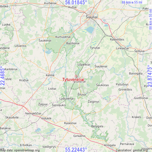
Tytuvėnėliai GPS coordinates[2]
55° 37' 24.42" North, 23° 10' 17.832" East
| Map corner | latitude | longitude |
|---|---|---|
| Upper-left | 56.01845°, | 22.4685° |
| Center: | 55.62345°, | 23.17162° |
| Lower-right: | 55.22443°, | 23.87475° |
| Map W x H: | 88.3×88.3 km | = 54.9×54.9mi |
| max Lat: | 56.36149° ⇑29.9% North |
| Tytuvėnėliai: | 55.62345° |
| min Lat: | ⇓70.1% South 54.01573° |
| min Long | Tytuvėnėliai | max Long |
| 20.99651° | 23.17162° | 26.43984° |
| W 30.6%⇐ | ⇒69.4% E |
Elevation
Elevation of Tytuvėnėliai is 120 m = 394 ft, and this is 29.3 m = 96 ft above average elevation for this country.
| Max E: |
204 m = 669 ft | 27.6% |
| Tytuvėnėliai | 120 m 394 ft | |
| Avg. | 90.7 m = 298 ft | |
Min E: |
-1 m = -3 ft | 72.4% |
See also: Lithuania elevation on elevation.city.
Geographical zone
Tytuvėnėliai is located in North temperate zone (between Tropic of Cancer and the Arctic Circle). Distance of this North polar circle is 1216.4 km =755.8 mi to North.| Distance of | km | miles | from Tytuvėnėliai |
|---|---|---|---|
| North Pole | 3822.3 | 2375.1 | to North |
| Arctic Circle | 1216.4 | 755.8 | to North |
| Tropic Cancer | 3578.8 | 2223.8 | to South |
| Equator | 6184.7 | 3843 | to South |


Nearby cities:
15 places around Tytuvėnėliai: (largest is in red/bold)
• Ariogala
44.6 km =27.7 mi,  154°
154°
• Būgai
42.4 km =26.3 mi,  236°
236°
• Dotnuva
53.1 km =33 mi,  122°
122°
• Gelgaudiškis
62 km =38.5 mi,  191°
191°
• Kelmė
14.9 km =9.3 mi,  272°
272°
• Kuršėnai
44.7 km =27.8 mi,  340°
340°
• Kėdainiai
62.8 km =39 mi,  126°
126°
• Naujamiestis
62 km =38.5 mi,  83°
83°
• Pakruojis
58.2 km =36.2 mi,  47°
47°
• Radviliskis
31.2 km =19.4 mi, 46°
• Raseiniai
27.3 km =17 mi, 186°
• Užventis
37.1 km =23.1 mi,  298°
298°
• Varniai
51.9 km =32.2 mi,  285°
285°
• Šeduva
39.2 km =24.4 mi,  69°
69°
• Šiauliai
35.6 km =22.1 mi,  14°
14°
Sources, notices
• [Note1] Compared only with cities in Lithuania existing in our database
• [Src1] Map data: © OpenStreetMap contributors (CC-BY-SA)
• [Src2] Other city data from geonames.org with taken over terms of usage.
• [Src3] Geographical zone / Annual Mean Temperature by Robert A. Rohde @ Wikipedia
