Wilwerwiltz geodata
Wilwerwiltz (Wiltz) is a seat of a third-order administrative division; located in Luxembourg in Europe/Luxembourg (GMT+2) time zone. With population of 249 people, there are 166 cities with bigger population in this country. Compared to other cities in Luxembourg, 97.2% of cities are located further ↓South; 73.4% of cities are located further →East and 62.7% of cities have lower elevation than Wilwerwiltz. Note1


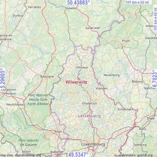
Wilwerwiltz GPS coordinates[2]
49° 59' 20.004" North, 5° 59' 57.012" East
| Map corner | latitude | longitude |
|---|---|---|
| Upper-left | 50.43883°, | 5.29605° |
| Center: | 49.98889°, | 5.99917° |
| Lower-right: | 49.5347°, | 6.7023° |
| Map W x H: | 100.5×100.5 km | = 62.4×62.4mi |
| max Lat: | 50.13722° ⇑2.8% North |
| Wilwerwiltz: | 49.98889° |
| min Lat: | ⇓97.2% South 49.45964° |
| min Long | Wilwerwiltz | max Long |
| 5.76583° | 5.99917° | 6.50532° |
| W 26.6%⇐ | ⇒73.4% E |
Elevation
Elevation of Wilwerwiltz is 299 m = 981 ft, and this is 17 m = 56 ft above average elevation for this country.
| Max E: |
502 m = 1647 ft | 37.3% |
| Wilwerwiltz | 299 m 981 ft | |
| Avg. | 282 m = 925 ft | |
Min E: |
143 m = 469 ft | 62.7% |
See also: Luxembourg elevation on elevation.city.
Geographical zone
Wilwerwiltz is located in North temperate zone (between Tropic of Cancer and the Arctic Circle). Distance of this North polar circle is 1842.9 km =1145.1 mi to North.| Distance of | km | miles | from Wilwerwiltz |
|---|---|---|---|
| North Pole | 4448.8 | 2764.4 | to North |
| Arctic Circle | 1842.9 | 1145.1 | to North |
| Tropic Cancer | 2952.3 | 1834.5 | to South |
| Equator | 5558.2 | 3453.7 | to South |


Nearby cities:
15 places around Wilwerwiltz: (largest is in red/bold)
• Bavigne
13 km =8.1 mi,  235°
235°
• Bourscheid
10.2 km =6.3 mi,  151°
151°
• Clervaux
7.7 km =4.8 mi,  17°
17°
• Erpeldange
16.1 km =10 mi, 149°
• Esch-sur-Sûre
9.7 km =6 mi,  207°
207°
• Goesdorf
7.9 km =4.9 mi,  197°
197°
• Hosingen
7 km =4.3 mi,  68°
68°
• Niederfeulen
15.2 km =9.4 mi,  166°
166°
• Putscheid
10.8 km =6.7 mi,  106°
106°
• Troisvierges
14.7 km =9.1 mi,  0°
0°
• Vianden
16.2 km =10.1 mi, 111°
• Warken
15.7 km =9.8 mi,  157°
157°
• Wiltz
5.3 km =3.3 mi, 240°
• Wincrange
9.2 km =5.7 mi,  321°
321°
• Winseler
8.1 km =5 mi,  253°
253°
Sources, notices
• [Note1] Compared only with cities in Luxembourg existing in our database
• [Src1] Map data: © OpenStreetMap contributors (CC-BY-SA)
• [Src2] Other city data from geonames.org with taken over terms of usage.
• [Src3] Geographical zone / Annual Mean Temperature by Robert A. Rohde @ Wikipedia
