Bourscheid geodata
Bourscheid (Diekirch) is a seat of a third-order administrative division; located in Luxembourg in Europe/Luxembourg (GMT+2) time zone. With population of 275 people, there are 163 cities with bigger population in this country. Compared to other cities in Luxembourg, 92.7% of cities are located further ↓South; 59.3% of cities are located further →East and 95.5% of cities have lower elevation than Bourscheid. Note1


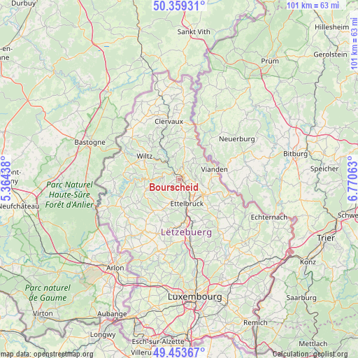
Bourscheid GPS coordinates[2]
49° 54' 31.032" North, 6° 4' 3" East
| Map corner | latitude | longitude |
|---|---|---|
| Upper-left | 50.35931°, | 5.36438° |
| Center: | 49.90862°, | 6.0675° |
| Lower-right: | 49.45367°, | 6.77063° |
| Map W x H: | 100.7×100.7 km | = 62.6×62.6mi |
| max Lat: | 50.13722° ⇑7.3% North |
| Bourscheid: | 49.90862° |
| min Lat: | ⇓92.7% South 49.45964° |
| min Long | Bourscheid | max Long |
| 5.76583° | 6.0675° | 6.50532° |
| W 40.7%⇐ | ⇒59.3% E |
Elevation
Elevation of Bourscheid is 442 m = 1450 ft, and this is 160 m = 525 ft above average elevation for this country.
| Max E: |
502 m = 1647 ft | 4.5% |
| Bourscheid | 442 m 1450 ft | |
| Avg. | 282 m = 925 ft | |
Min E: |
143 m = 469 ft | 95.5% |
See also: Luxembourg elevation on elevation.city.
Geographical zone
Bourscheid is located in North temperate zone (between Tropic of Cancer and the Arctic Circle). Distance of this North polar circle is 1851.9 km =1150.7 mi to North.| Distance of | km | miles | from Bourscheid |
|---|---|---|---|
| North Pole | 4457.7 | 2769.9 | to North |
| Arctic Circle | 1851.9 | 1150.7 | to North |
| Tropic Cancer | 2943.4 | 1828.9 | to South |
| Equator | 5549.3 | 3448.2 | to South |


Nearby cities:
15 places around Bourscheid: (largest is in red/bold)
• Diekirch
7.8 km =4.8 mi,  125°
125°
• Erpeldange
5.9 km =3.7 mi,  145°
145°
• Esch-sur-Sûre
9.4 km =5.8 mi,  271°
271°
• Ettelbruck
7.3 km =4.5 mi,  158°
158°
• Gilsdorf
9.4 km =5.8 mi,  121°
121°
• Goesdorf
7.4 km =4.6 mi,  280°
280°
• Ingeldorf
7.9 km =4.9 mi,  142°
142°
• Mertzig
9.4 km =5.8 mi,  207°
207°
• Niederfeulen
6.1 km =3.8 mi,  193°
193°
• Putscheid
7.9 km =4.9 mi,  42°
42°
• Schieren
9 km =5.6 mi,  165°
165°
• Tandel
8.4 km =5.2 mi,  98°
98°
• Vianden
10.5 km =6.5 mi,  73°
73°
• Warken
5.6 km =3.5 mi, 167°
• Wilwerwiltz
10.2 km =6.3 mi,  331°
331°
Sources, notices
• [Note1] Compared only with cities in Luxembourg existing in our database
• [Src1] Map data: © OpenStreetMap contributors (CC-BY-SA)
• [Src2] Other city data from geonames.org with taken over terms of usage.
• [Src3] Geographical zone / Annual Mean Temperature by Robert A. Rohde @ Wikipedia
