Hosingen geodata
Hosingen (Clervaux) is a seat of a third-order administrative division; located in Luxembourg in Europe/Luxembourg (GMT+2) time zone. With population of 811 people, there are 98 cities with bigger population in this country. Compared to other cities in Luxembourg, 97.7% of cities are located further ↓South; 54.2% of cities are located further →East and 99.4% of cities have lower elevation than Hosingen. Note1


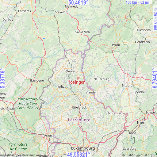
Hosingen GPS coordinates[2]
50° 0' 43.848" North, 6° 5' 27.204" East
| Map corner | latitude | longitude |
|---|---|---|
| Upper-left | 50.4619°, | 5.38776° |
| Center: | 50.01218°, | 6.09089° |
| Lower-right: | 49.55821°, | 6.79401° |
| Map W x H: | 100.5×100.5 km | = 62.4×62.4mi |
| max Lat: | 50.13722° ⇑2.3% North |
| Hosingen: | 50.01218° |
| min Lat: | ⇓97.7% South 49.45964° |
| min Long | Hosingen | max Long |
| 5.76583° | 6.09089° | 6.50532° |
| W 45.8%⇐ | ⇒54.2% E |
Elevation
Elevation of Hosingen is 498 m = 1634 ft, and this is 216 m = 709 ft above average elevation for this country.
| Max E: |
502 m = 1647 ft | 0.59999999999999% |
| Hosingen | 498 m 1634 ft | |
| Avg. | 282 m = 925 ft | |
Min E: |
143 m = 469 ft | 99.4% |
See also: Luxembourg elevation on elevation.city.
Geographical zone
Hosingen is located in North temperate zone (between Tropic of Cancer and the Arctic Circle). Distance of this North polar circle is 1840.3 km =1143.5 mi to North.| Distance of | km | miles | from Hosingen |
|---|---|---|---|
| North Pole | 4446.2 | 2762.7 | to North |
| Arctic Circle | 1840.3 | 1143.5 | to North |
| Tropic Cancer | 2954.9 | 1836.1 | to South |
| Equator | 5560.8 | 3455.3 | to South |


Nearby cities:
15 places around Hosingen: (largest is in red/bold)
• Bourscheid
11.6 km =7.2 mi,  188°
188°
• Clervaux
6.4 km =4 mi,  318°
318°
• Diekirch
16.7 km =10.4 mi,  163°
163°
• Erpeldange
16.5 km =10.3 mi,  174°
174°
• Esch-sur-Sûre
15.7 km =9.8 mi,  224°
224°
• Goesdorf
13.5 km =8.4 mi, 221°
• Putscheid
6.8 km =4.2 mi,  146°
146°
• Tandel
14.4 km =8.9 mi, 152°
• Troisvierges
13.7 km =8.5 mi,  331°
331°
• Vianden
12 km =7.5 mi,  135°
135°
• Weiswampach
13.9 km =8.6 mi,  355°
355°
• Wiltz
12.4 km =7.7 mi,  245°
245°
• Wilwerwiltz
7 km =4.3 mi, 248°
• Wincrange
13.1 km =8.1 mi,  290°
290°
• Winseler
15.2 km =9.4 mi, 251°
Sources, notices
• [Note1] Compared only with cities in Luxembourg existing in our database
• [Src1] Map data: © OpenStreetMap contributors (CC-BY-SA)
• [Src2] Other city data from geonames.org with taken over terms of usage.
• [Src3] Geographical zone / Annual Mean Temperature by Robert A. Rohde @ Wikipedia
