Wiltz geodata
Wiltz is a seat of a first-order administrative division; located in Luxembourg in Europe/Luxembourg (GMT+2) time zone. With population of 4,816 people, there are 14 cities with bigger population in this country. Compared to other cities in Luxembourg, 96% of cities are located further ↓South; 84.2% of cities are located further →East and 93.8% of cities have lower elevation than Wiltz. Note1


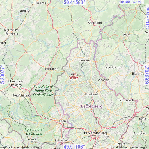
Wiltz GPS coordinates[2]
49° 57' 55.692" North, 5° 56' 2.04" East
| Map corner | latitude | longitude |
|---|---|---|
| Upper-left | 50.41563°, | 5.23077° |
| Center: | 49.96547°, | 5.9339° |
| Lower-right: | 49.51106°, | 6.63702° |
| Map W x H: | 100.6×100.6 km | = 62.5×62.5mi |
| max Lat: | 50.13722° ⇑4% North |
| Wiltz: | 49.96547° |
| min Lat: | ⇓96% South 49.45964° |
| min Long | Wiltz | max Long |
| 5.76583° | 5.9339° | 6.50532° |
| W 15.8%⇐ | ⇒84.2% E |
Elevation
Elevation of Wiltz is 382 m = 1253 ft, and this is 100 m = 328 ft above average elevation for this country.
| Max E: |
502 m = 1647 ft | 6.2% |
| Wiltz | 382 m 1253 ft | |
| Avg. | 282 m = 925 ft | |
Min E: |
143 m = 469 ft | 93.8% |
See also: Luxembourg elevation on elevation.city.
Geographical zone
Wiltz is located in North temperate zone (between Tropic of Cancer and the Arctic Circle). Distance of this North polar circle is 1845.5 km =1146.7 mi to North.| Distance of | km | miles | from Wiltz |
|---|---|---|---|
| North Pole | 4451.4 | 2766 | to North |
| Arctic Circle | 1845.5 | 1146.7 | to North |
| Tropic Cancer | 2949.7 | 1832.9 | to South |
| Equator | 5555.6 | 3452.1 | to South |


Nearby cities:
15 places around Wiltz: (largest is in red/bold)
• Bavigne
7.7 km =4.8 mi,  231°
231°
• Boulaide
12.1 km =7.5 mi,  224°
224°
• Bourscheid
11.5 km =7.1 mi,  123°
123°
• Clervaux
12.1 km =7.5 mi,  35°
35°
• Esch-sur-Sûre
6 km =3.7 mi,  178°
178°
• Goesdorf
5.4 km =3.4 mi,  154°
154°
• Grosbous
15.5 km =9.6 mi,  171°
171°
• Hosingen
12.4 km =7.7 mi,  65°
65°
• Mertzig
15.6 km =9.7 mi,  160°
160°
• Niederfeulen
14.7 km =9.1 mi, 146°
• Putscheid
15 km =9.3 mi,  91°
91°
• Wahl
14.5 km =9 mi,  187°
187°
• Wilwerwiltz
5.3 km =3.3 mi,  60°
60°
• Wincrange
9.8 km =6.1 mi,  353°
353°
• Winseler
3.1 km =1.9 mi,  274°
274°
Sources, notices
• [Note1] Compared only with cities in Luxembourg existing in our database
• [Src1] Map data: © OpenStreetMap contributors (CC-BY-SA)
• [Src2] Other city data from geonames.org with taken over terms of usage.
• [Src3] Geographical zone / Annual Mean Temperature by Robert A. Rohde @ Wikipedia
