Putscheid geodata
Putscheid (Vianden) is a seat of a third-order administrative division; located in Luxembourg in Europe/Luxembourg (GMT+2) time zone. With population of 38 people, there are 176 cities with bigger population in this country. Compared to other cities in Luxembourg, 95.5% of cities are located further ↓South; 59.3% of cities are located further ←West and 94.4% of cities have lower elevation than Putscheid. Note1


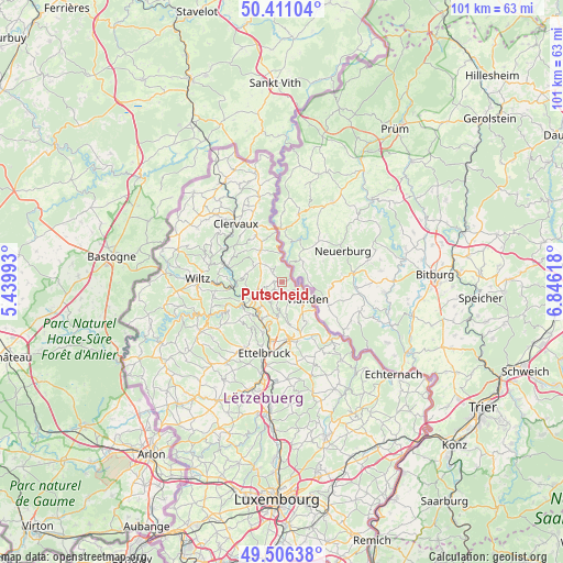
Putscheid GPS coordinates[2]
49° 57' 38.988" North, 6° 8' 35.016" East
| Map corner | latitude | longitude |
|---|---|---|
| Upper-left | 50.41104°, | 5.43993° |
| Center: | 49.96083°, | 6.14306° |
| Lower-right: | 49.50638°, | 6.84618° |
| Map W x H: | 100.6×100.6 km | = 62.5×62.5mi |
| max Lat: | 50.13722° ⇑4.5% North |
| Putscheid: | 49.96083° |
| min Lat: | ⇓95.5% South 49.45964° |
| min Long | Putscheid | max Long |
| 5.76583° | 6.14306° | 6.50532° |
| W 59.3%⇐ | ⇒40.7% E |
Elevation
Elevation of Putscheid is 415 m = 1362 ft, and this is 133 m = 436 ft above average elevation for this country.
| Max E: |
502 m = 1647 ft | 5.6% |
| Putscheid | 415 m 1362 ft | |
| Avg. | 282 m = 925 ft | |
Min E: |
143 m = 469 ft | 94.4% |
See also: Luxembourg elevation on elevation.city.
Geographical zone
Putscheid is located in North temperate zone (between Tropic of Cancer and the Arctic Circle). Distance of this North polar circle is 1846.1 km =1147.1 mi to North.| Distance of | km | miles | from Putscheid |
|---|---|---|---|
| North Pole | 4451.9 | 2766.3 | to North |
| Arctic Circle | 1846.1 | 1147.1 | to North |
| Tropic Cancer | 2949.2 | 1832.5 | to South |
| Equator | 5555.1 | 3451.8 | to South |


Nearby cities:
15 places around Putscheid: (largest is in red/bold)
• Bettendorf
10.8 km =6.7 mi,  150°
150°
• Bourscheid
7.9 km =4.9 mi,  222°
222°
• Clervaux
13.1 km =8.1 mi,  322°
322°
• Diekirch
10.4 km =6.5 mi,  174°
174°
• Erpeldange
10.9 km =6.8 mi,  190°
190°
• Ettelbruck
12.9 km =8 mi, 192°
• Gilsdorf
11 km =6.8 mi, 166°
• Goesdorf
13.4 km =8.3 mi,  250°
250°
• Hosingen
6.8 km =4.2 mi,  326°
326°
• Ingeldorf
12.1 km =7.5 mi,  182°
182°
• Reisdorf
13.6 km =8.5 mi,  138°
138°
• Tandel
7.6 km =4.7 mi,  157°
157°
• Vianden
5.5 km =3.4 mi,  121°
121°
• Warken
12.1 km =7.5 mi,  200°
200°
• Wilwerwiltz
10.8 km =6.7 mi,  286°
286°
Sources, notices
• [Note1] Compared only with cities in Luxembourg existing in our database
• [Src1] Map data: © OpenStreetMap contributors (CC-BY-SA)
• [Src2] Other city data from geonames.org with taken over terms of usage.
• [Src3] Geographical zone / Annual Mean Temperature by Robert A. Rohde @ Wikipedia
