Tandel geodata
Tandel (Vianden) is a seat of a third-order administrative division; located in Luxembourg in Europe/Luxembourg (GMT+2) time zone. With population of 89 people, there are 175 cities with bigger population in this country. Compared to other cities in Luxembourg, 92.1% of cities are located further ↓South; 66.1% of cities are located further ←West and 78% of cities have higher elevation than Tandel. Note1


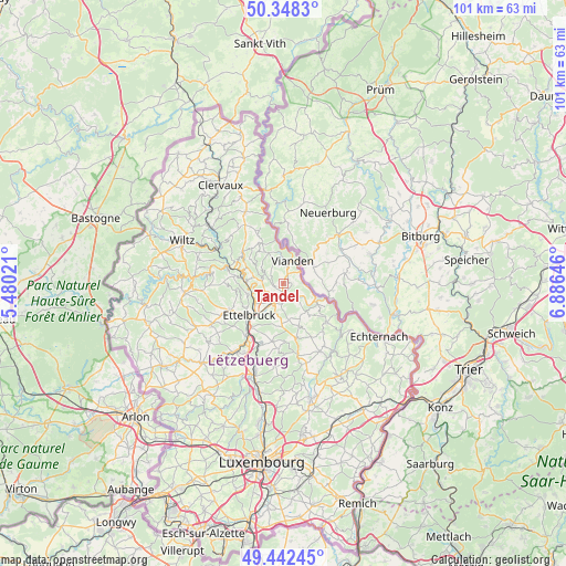
Tandel GPS coordinates[2]
49° 53' 51" North, 6° 10' 59.988" East
| Map corner | latitude | longitude |
|---|---|---|
| Upper-left | 50.3483°, | 5.48021° |
| Center: | 49.8975°, | 6.18333° |
| Lower-right: | 49.44245°, | 6.88646° |
| Map W x H: | 100.7×100.7 km | = 62.6×62.6mi |
| max Lat: | 50.13722° ⇑7.9% North |
| Tandel: | 49.8975° |
| min Lat: | ⇓92.1% South 49.45964° |
| min Long | Tandel | max Long |
| 5.76583° | 6.18333° | 6.50532° |
| W 66.1%⇐ | ⇒33.9% E |
Elevation
Elevation of Tandel is 229 m = 751 ft, and this is 53 m = 174 ft below average elevation for this country.
| Max E: |
502 m = 1647 ft | 78% |
| Avg. | 282 m = 925 ft | |
| Tandel | 229 m = 751 ft | |
Min E: |
143 m = 469 ft | 22% |
See also: Luxembourg elevation on elevation.city.
Geographical zone
Tandel is located in North temperate zone (between Tropic of Cancer and the Arctic Circle). Distance of this North polar circle is 1853.1 km =1151.5 mi to North.| Distance of | km | miles | from Tandel |
|---|---|---|---|
| North Pole | 4459 | 2770.7 | to North |
| Arctic Circle | 1853.1 | 1151.5 | to North |
| Tropic Cancer | 2942.2 | 1828.2 | to South |
| Equator | 5548.1 | 3447.4 | to South |


Nearby cities:
15 places around Tandel: (largest is in red/bold)
• Beaufort
10.4 km =6.5 mi,  131°
131°
• Bettendorf
3.4 km =2.1 mi, 132°
• Bourscheid
8.4 km =5.2 mi,  278°
278°
• Diekirch
3.8 km =2.4 mi,  210°
210°
• Erpeldange
6.1 km =3.8 mi,  233°
233°
• Ettelbruck
7.9 km =4.9 mi, 225°
• Gilsdorf
3.6 km =2.2 mi,  184°
184°
• Ingeldorf
6.1 km =3.8 mi, 214°
• Medernach
10 km =6.2 mi,  166°
166°
• Niederfeulen
10.8 km =6.7 mi,  244°
244°
• Putscheid
7.6 km =4.7 mi,  337°
337°
• Reisdorf
6.9 km =4.3 mi,  117°
117°
• Schieren
9.6 km =6 mi,  219°
219°
• Vianden
4.6 km =2.9 mi,  23°
23°
• Warken
8.3 km =5.2 mi, 239°
Sources, notices
• [Note1] Compared only with cities in Luxembourg existing in our database
• [Src1] Map data: © OpenStreetMap contributors (CC-BY-SA)
• [Src2] Other city data from geonames.org with taken over terms of usage.
• [Src3] Geographical zone / Annual Mean Temperature by Robert A. Rohde @ Wikipedia
