Medernach geodata
Medernach (Diekirch) is a seat of a third-order administrative division; located in Luxembourg in Europe/Luxembourg (GMT+2) time zone. With population of 907 people, there are 88 cities with bigger population in this country. Compared to other cities in Luxembourg, 79.7% of cities are located further ↓South; 68.9% of cities are located further ←West and 66.7% of cities have higher elevation than Medernach. Note1


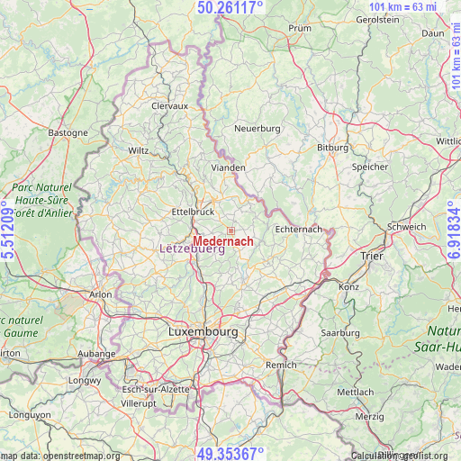
Medernach GPS coordinates[2]
49° 48' 34.38" North, 6° 12' 54.756" East
| Map corner | latitude | longitude |
|---|---|---|
| Upper-left | 50.26117°, | 5.51209° |
| Center: | 49.80955°, | 6.21521° |
| Lower-right: | 49.35367°, | 6.91834° |
| Map W x H: | 100.9×100.9 km | = 62.7×62.7mi |
| max Lat: | 50.13722° ⇑20.3% North |
| Medernach: | 49.80955° |
| min Lat: | ⇓79.7% South 49.45964° |
| min Long | Medernach | max Long |
| 5.76583° | 6.21521° | 6.50532° |
| W 68.9%⇐ | ⇒31.1% E |
Elevation
Elevation of Medernach is 259 m = 850 ft, and this is 23 m = 75 ft below average elevation for this country.
| Max E: |
502 m = 1647 ft | 66.7% |
| Avg. | 282 m = 925 ft | |
| Medernach | 259 m = 850 ft | |
Min E: |
143 m = 469 ft | 33.3% |
See also: Luxembourg elevation on elevation.city.
Geographical zone
Medernach is located in North temperate zone (between Tropic of Cancer and the Arctic Circle). Distance of this North polar circle is 1862.9 km =1157.6 mi to North.| Distance of | km | miles | from Medernach |
|---|---|---|---|
| North Pole | 4468.8 | 2776.8 | to North |
| Arctic Circle | 1862.9 | 1157.6 | to North |
| Tropic Cancer | 2932.4 | 1822.1 | to South |
| Equator | 5538.3 | 3441.3 | to South |


Nearby cities:
15 places around Medernach: (largest is in red/bold)
• Beaufort
6.2 km =3.9 mi,  61°
61°
• Beringen
9.1 km =5.7 mi,  231°
231°
• Bettendorf
7.5 km =4.7 mi,  1°
1°
• Colmar
8.5 km =5.3 mi,  270°
270°
• Diekirch
7.7 km =4.8 mi,  326°
326°
• Ettelbruck
9 km =5.6 mi,  297°
297°
• Fischbach
7.4 km =4.6 mi,  195°
195°
• Gilsdorf
6.7 km =4.2 mi,  337°
337°
• Heffingen
4.9 km =3 mi,  158°
158°
• Ingeldorf
7.5 km =4.7 mi,  309°
309°
• Larochette
2.9 km =1.8 mi,  174°
174°
• Nommern
3.8 km =2.4 mi, 229°
• Reisdorf
7.6 km =4.7 mi,  29°
29°
• Schieren
8.7 km =5.4 mi,  285°
285°
• Waldbillig
5.2 km =3.2 mi,  106°
106°
Sources, notices
• [Note1] Compared only with cities in Luxembourg existing in our database
• [Src1] Map data: © OpenStreetMap contributors (CC-BY-SA)
• [Src2] Other city data from geonames.org with taken over terms of usage.
• [Src3] Geographical zone / Annual Mean Temperature by Robert A. Rohde @ Wikipedia
