Reisdorf geodata
Reisdorf (Diekirch) is a seat of a third-order administrative division; located in Luxembourg in Europe/Luxembourg (GMT+2) time zone. With population of 493 people, there are 148 cities with bigger population in this country. Compared to other cities in Luxembourg, 90.4% of cities are located further ↓South; 79.7% of cities are located further ←West and 90.4% of cities have higher elevation than Reisdorf. Note1


Reisdorf GPS coordinates[2]
49° 52' 6.996" North, 6° 16' 4.008" East
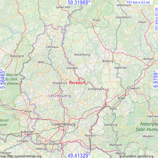
| Map corner | latitude | longitude |
|---|---|---|
| Upper-left | 50.31968°, | 5.56465° |
| Center: | 49.86861°, | 6.26778° |
| Lower-right: | 49.41329°, | 6.9709° |
| Map W x H: | 100.8×100.8 km | = 62.6×62.6mi |
| max Lat: | 50.13722° ⇑9.6% North |
| Reisdorf: | 49.86861° |
| min Lat: | ⇓90.4% South 49.45964° |
| min Long | Reisdorf | max Long |
| 5.76583° | 6.26778° | 6.50532° |
| W 79.7%⇐ | ⇒20.3% E |
Elevation
Elevation of Reisdorf is 191 m = 627 ft, and this is 91 m = 299 ft below average elevation for this country.
| Max E: |
502 m = 1647 ft | 90.4% |
| Avg. | 282 m = 925 ft | |
| Reisdorf | 191 m = 627 ft | |
Min E: |
143 m = 469 ft | 9.6% |
See also: Luxembourg elevation on elevation.city.
Geographical zone
Reisdorf is located in North temperate zone (between Tropic of Cancer and the Arctic Circle). Distance of this North polar circle is 1856.3 km =1153.5 mi to North.| Distance of | km | miles | from Reisdorf |
|---|---|---|---|
| North Pole | 4462.2 | 2772.7 | to North |
| Arctic Circle | 1856.3 | 1153.5 | to North |
| Tropic Cancer | 2939 | 1826.2 | to South |
| Equator | 5544.9 | 3445.4 | to South |


Nearby cities:
15 places around Reisdorf: (largest is in red/bold)
• Beaufort
4 km =2.5 mi,  154°
154°
• Berdorf
7.9 km =4.9 mi,  132°
132°
• Bettendorf
3.7 km =2.3 mi,  284°
284°
• Consdorf
11.1 km =6.9 mi, 152°
• Diekirch
8 km =5 mi,  269°
269°
• Erpeldange
11 km =6.8 mi, 267°
• Gilsdorf
6.3 km =3.9 mi, 266°
• Heffingen
11.2 km =7 mi,  190°
190°
• Ingeldorf
9.7 km =6 mi,  259°
259°
• Larochette
10.1 km =6.3 mi,  200°
200°
• Medernach
7.6 km =4.7 mi,  209°
209°
• Nommern
11.3 km =7 mi,  216°
216°
• Tandel
6.9 km =4.3 mi,  297°
297°
• Vianden
8.5 km =5.3 mi,  330°
330°
• Waldbillig
8.1 km =5 mi,  171°
171°
Sources, notices
• [Note1] Compared only with cities in Luxembourg existing in our database
• [Src1] Map data: © OpenStreetMap contributors (CC-BY-SA)
• [Src2] Other city data from geonames.org with taken over terms of usage.
• [Src3] Geographical zone / Annual Mean Temperature by Robert A. Rohde @ Wikipedia
