Hautcharage geodata
Hautcharage (Capellen) is a populated place; located in Luxembourg in Europe/Luxembourg (GMT+2) time zone. With population of 1,495 people, there are 51 cities with bigger population in this country. Compared to other cities in Luxembourg, 72.3% of cities are located further ↑North; 89.3% of cities are located further →East and 54.2% of cities have lower elevation than Hautcharage. Note1


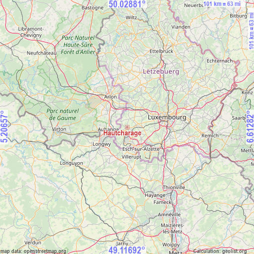
Hautcharage GPS coordinates[2]
49° 34' 29.964" North, 5° 54' 34.92" East
| Map corner | latitude | longitude |
|---|---|---|
| Upper-left | 50.02881°, | 5.20657° |
| Center: | 49.57499°, | 5.9097° |
| Lower-right: | 49.11692°, | 6.61282° |
| Map W x H: | 101.4×101.4 km | = 63×63mi |
| max Lat: | 50.13722° ⇑72.3% North |
| Hautcharage: | 49.57499° |
| min Lat: | ⇓27.7% South 49.45964° |
| min Long | Hautcharage | max Long |
| 5.76583° | 5.9097° | 6.50532° |
| W 10.7%⇐ | ⇒89.3% E |
Elevation
Elevation of Hautcharage is 289 m = 948 ft, and this is 7 m = 23 ft above average elevation for this country.
| Max E: |
502 m = 1647 ft | 45.8% |
| Hautcharage | 289 m 948 ft | |
| Avg. | 282 m = 925 ft | |
Min E: |
143 m = 469 ft | 54.2% |
See also: Luxembourg elevation on elevation.city.
Geographical zone
Hautcharage is located in North temperate zone (between Tropic of Cancer and the Arctic Circle). Distance of this North polar circle is 1889 km =1173.8 mi to North.| Distance of | km | miles | from Hautcharage |
|---|---|---|---|
| North Pole | 4494.8 | 2792.9 | to North |
| Arctic Circle | 1889 | 1173.8 | to North |
| Tropic Cancer | 2906.3 | 1805.9 | to South |
| Equator | 5512.2 | 3425.1 | to South |


Nearby cities:
15 places around Hautcharage: (largest is in red/bold)
• Bascharage
0.9 km =0.6 mi,  191°
191°
• Bettange-sur-Mess
5.3 km =3.3 mi,  88°
88°
• Clemency
3.4 km =2.1 mi,  314°
314°
• Differdange
5.8 km =3.6 mi, 193°
• Dippach
5.5 km =3.4 mi,  75°
75°
• Garnich
5.6 km =3.5 mi,  33°
33°
• Lamadelaine
5 km =3.1 mi,  230°
230°
• Linger
1.9 km =1.2 mi,  238°
238°
• Niedercorn
4.5 km =2.8 mi,  195°
195°
• Obercorn
6.9 km =4.3 mi, 188°
• Pétange
2.8 km =1.7 mi, 228°
• Rodange
5.9 km =3.7 mi, 237°
• Sanem
3.3 km =2.1 mi,  155°
155°
• Schouweiler
3.5 km =2.2 mi, 76°
• Soleuvre
6.3 km =3.9 mi, 161°
Sources, notices
• [Note1] Compared only with cities in Luxembourg existing in our database
• [Src1] Map data: © OpenStreetMap contributors (CC-BY-SA)
• [Src2] Other city data from geonames.org with taken over terms of usage.
• [Src3] Geographical zone / Annual Mean Temperature by Robert A. Rohde @ Wikipedia
