Garnich geodata
Garnich (Capellen) is a seat of a third-order administrative division; located in Luxembourg in Europe/Luxembourg (GMT+2) time zone. With population of 824 people, there are 96 cities with bigger population in this country. Compared to other cities in Luxembourg, 61.6% of cities are located further ↑North; 81.4% of cities are located further →East and 87% of cities have lower elevation than Garnich. Note1


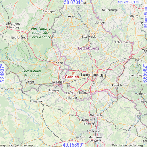
Garnich GPS coordinates[2]
49° 37' 0.012" North, 5° 57' 9" East
| Map corner | latitude | longitude |
|---|---|---|
| Upper-left | 50.0701°, | 5.24937° |
| Center: | 49.61667°, | 5.9525° |
| Lower-right: | 49.15899°, | 6.65562° |
| Map W x H: | 101.3×101.3 km | = 62.9×62.9mi |
| max Lat: | 50.13722° ⇑61.6% North |
| Garnich: | 49.61667° |
| min Lat: | ⇓38.4% South 49.45964° |
| min Long | Garnich | max Long |
| 5.76583° | 5.9525° | 6.50532° |
| W 18.6%⇐ | ⇒81.4% E |
Elevation
Elevation of Garnich is 339 m = 1112 ft, and this is 57 m = 187 ft above average elevation for this country.
| Max E: |
502 m = 1647 ft | 13% |
| Garnich | 339 m 1112 ft | |
| Avg. | 282 m = 925 ft | |
Min E: |
143 m = 469 ft | 87% |
See also: Luxembourg elevation on elevation.city.
Geographical zone
Garnich is located in North temperate zone (between Tropic of Cancer and the Arctic Circle). Distance of this North polar circle is 1884.3 km =1170.8 mi to North.| Distance of | km | miles | from Garnich |
|---|---|---|---|
| North Pole | 4490.2 | 2790.1 | to North |
| Arctic Circle | 1884.3 | 1170.8 | to North |
| Tropic Cancer | 2910.9 | 1808.7 | to South |
| Equator | 5516.9 | 3428 | to South |


Nearby cities:
15 places around Garnich: (largest is in red/bold)
• Bascharage
6.4 km =4 mi,  210°
210°
• Bertrange
7.1 km =4.4 mi,  95°
95°
• Bettange-sur-Mess
5.1 km =3.2 mi,  153°
153°
• Capellen
4.2 km =2.6 mi,  41°
41°
• Clemency
6 km =3.7 mi,  248°
248°
• Dippach
4 km =2.5 mi, 146°
• Hagen
3.9 km =2.4 mi,  337°
337°
• Hautcharage
5.6 km =3.5 mi, 213°
• Holzem
2.7 km =1.7 mi,  90°
90°
• Kleinbettingen
4.2 km =2.6 mi,  321°
321°
• Koerich
5.9 km =3.7 mi,  358°
358°
• Mamer
5.2 km =3.2 mi,  76°
76°
• Olm
5.7 km =3.5 mi, 37°
• Schouweiler
3.8 km =2.4 mi,  175°
175°
• Steinfort
5.5 km =3.4 mi,  334°
334°
Sources, notices
• [Note1] Compared only with cities in Luxembourg existing in our database
• [Src1] Map data: © OpenStreetMap contributors (CC-BY-SA)
• [Src2] Other city data from geonames.org with taken over terms of usage.
• [Src3] Geographical zone / Annual Mean Temperature by Robert A. Rohde @ Wikipedia
