Schouweiler geodata
Schouweiler (Capellen) is a populated place; located in Luxembourg in Europe/Luxembourg (GMT+2) time zone. With population of 1,090 people, there are 73 cities with bigger population in this country. Compared to other cities in Luxembourg, 70.6% of cities are located further ↑North; 80.8% of cities are located further →East and 81.4% of cities have lower elevation than Schouweiler. Note1


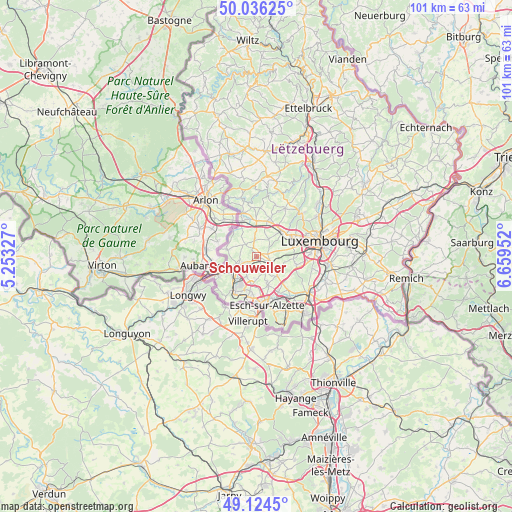
Schouweiler GPS coordinates[2]
49° 34' 57" North, 5° 57' 23.004" East
| Map corner | latitude | longitude |
|---|---|---|
| Upper-left | 50.03625°, | 5.25327° |
| Center: | 49.5825°, | 5.95639° |
| Lower-right: | 49.1245°, | 6.65952° |
| Map W x H: | 101.4×101.4 km | = 63×63mi |
| max Lat: | 50.13722° ⇑70.6% North |
| Schouweiler: | 49.5825° |
| min Lat: | ⇓29.4% South 49.45964° |
| min Long | Schouweiler | max Long |
| 5.76583° | 5.95639° | 6.50532° |
| W 19.2%⇐ | ⇒80.8% E |
Elevation
Elevation of Schouweiler is 331 m = 1086 ft, and this is 49 m = 161 ft above average elevation for this country.
| Max E: |
502 m = 1647 ft | 18.6% |
| Schouweiler | 331 m 1086 ft | |
| Avg. | 282 m = 925 ft | |
Min E: |
143 m = 469 ft | 81.4% |
See also: Luxembourg elevation on elevation.city.
Geographical zone
Schouweiler is located in North temperate zone (between Tropic of Cancer and the Arctic Circle). Distance of this North polar circle is 1888.1 km =1173.2 mi to North.| Distance of | km | miles | from Schouweiler |
|---|---|---|---|
| North Pole | 4494 | 2792.4 | to North |
| Arctic Circle | 1888.1 | 1173.2 | to North |
| Tropic Cancer | 2907.1 | 1806.4 | to South |
| Equator | 5513.1 | 3425.7 | to South |


Nearby cities:
15 places around Schouweiler: (largest is in red/bold)
• Bascharage
3.9 km =2.4 mi,  244°
244°
• Bettange-sur-Mess
2.1 km =1.3 mi,  110°
110°
• Clemency
6 km =3.7 mi,  285°
285°
• Dippach
2 km =1.2 mi,  75°
75°
• Ehlerange
6.5 km =4 mi,  173°
173°
• Garnich
3.8 km =2.4 mi,  355°
355°
• Hautcharage
3.5 km =2.2 mi,  256°
256°
• Holzem
4.5 km =2.8 mi,  32°
32°
• Linger
5.4 km =3.4 mi,  249°
249°
• Mamer
6.9 km =4.3 mi,  43°
43°
• Mondercange
6 km =3.7 mi,  157°
157°
• Pétange
6.1 km =3.8 mi, 243°
• Reckange-sur-Mess
4.4 km =2.7 mi,  120°
120°
• Sanem
4.3 km =2.7 mi,  207°
207°
• Soleuvre
6.9 km =4.3 mi,  191°
191°
Sources, notices
• [Note1] Compared only with cities in Luxembourg existing in our database
• [Src1] Map data: © OpenStreetMap contributors (CC-BY-SA)
• [Src2] Other city data from geonames.org with taken over terms of usage.
• [Src3] Geographical zone / Annual Mean Temperature by Robert A. Rohde @ Wikipedia
