Rodange geodata
Rodange (Esch-sur-Alzette) is a populated place; located in Luxembourg in Europe/Luxembourg (GMT+2) time zone. With population of 4,683 people, there are 16 cities with bigger population in this country. Compared to other cities in Luxembourg, 80.2% of cities are located further ↑North; 98.9% of cities are located further →East and 63.8% of cities have lower elevation than Rodange. Note1


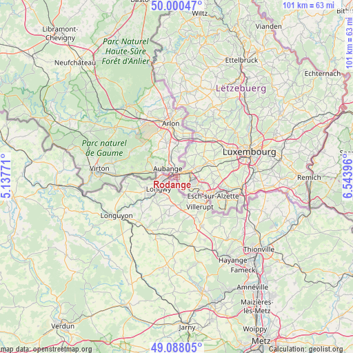
Rodange GPS coordinates[2]
49° 32' 47.004" North, 5° 50' 26.988" East
| Map corner | latitude | longitude |
|---|---|---|
| Upper-left | 50.00047°, | 5.13771° |
| Center: | 49.54639°, | 5.84083° |
| Lower-right: | 49.08805°, | 6.54396° |
| Map W x H: | 101.5×101.5 km | = 63.1×63.1mi |
| max Lat: | 50.13722° ⇑80.2% North |
| Rodange: | 49.54639° |
| min Lat: | ⇓19.8% South 49.45964° |
| min Long | Rodange | max Long |
| 5.76583° | 5.84083° | 6.50532° |
| W 1.1%⇐ | ⇒98.9% E |
Elevation
Elevation of Rodange is 300 m = 984 ft, and this is 18 m = 59 ft above average elevation for this country.
| Max E: |
502 m = 1647 ft | 36.2% |
| Rodange | 300 m 984 ft | |
| Avg. | 282 m = 925 ft | |
Min E: |
143 m = 469 ft | 63.8% |
See also: Luxembourg elevation on elevation.city.
Geographical zone
Rodange is located in North temperate zone (between Tropic of Cancer and the Arctic Circle). Distance of this North polar circle is 1892.1 km =1175.7 mi to North.| Distance of | km | miles | from Rodange |
|---|---|---|---|
| North Pole | 4498 | 2794.9 | to North |
| Arctic Circle | 1892.1 | 1175.7 | to North |
| Tropic Cancer | 2903.1 | 1803.9 | to South |
| Equator | 5509 | 3423.1 | to South |


Nearby cities:
15 places around Rodange: (largest is in red/bold)
• Bascharage
5.3 km =3.3 mi,  64°
64°
• Belvaux
7.2 km =4.5 mi,  123°
123°
• Clemency
6.1 km =3.8 mi,  24°
24°
• Differdange
4.4 km =2.7 mi, 124°
• Ehlerange
9.4 km =5.8 mi,  105°
105°
• Hautcharage
5.9 km =3.7 mi, 57°
• Lamadelaine
1.1 km =0.7 mi,  90°
90°
• Linger
4 km =2.5 mi, 56°
• Mondercange
10.7 km =6.6 mi,  97°
97°
• Niedercorn
3.9 km =2.4 mi, 106°
• Obercorn
5.4 km =3.4 mi,  132°
132°
• Pétange
3.2 km =2 mi,  65°
65°
• Sanem
6.4 km =4 mi, 88°
• Schouweiler
9.3 km =5.8 mi, 64°
• Soleuvre
7.5 km =4.7 mi, 111°
Sources, notices
• [Note1] Compared only with cities in Luxembourg existing in our database
• [Src1] Map data: © OpenStreetMap contributors (CC-BY-SA)
• [Src2] Other city data from geonames.org with taken over terms of usage.
• [Src3] Geographical zone / Annual Mean Temperature by Robert A. Rohde @ Wikipedia
