Dippach geodata
Dippach (Capellen) is a seat of a third-order administrative division; located in Luxembourg in Europe/Luxembourg (GMT+2) time zone. With population of 808 people, there are 99 cities with bigger population in this country. Compared to other cities in Luxembourg, 68.9% of cities are located further ↑North; 76.8% of cities are located further →East and 91% of cities have lower elevation than Dippach. Note1


Dippach GPS coordinates[2]
49° 35' 13.236" North, 5° 58' 59.88" East
| Map corner | latitude | longitude |
|---|---|---|
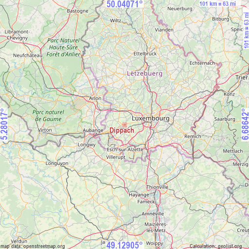
| Upper-left | 50.04071°, | 5.28017° |
| Center: | 49.58701°, | 5.9833° |
| Lower-right: | 49.12905°, | 6.68642° |
| Map W x H: | 101.4×101.4 km | = 63×63mi |
| max Lat: | 50.13722° ⇑68.9% North |
| Dippach: | 49.58701° |
| min Lat: | ⇓31.1% South 49.45964° |
| min Long | Dippach | max Long |
| 5.76583° | 5.9833° | 6.50532° |
| W 23.2%⇐ | ⇒76.8% E |
Elevation
Elevation of Dippach is 361 m = 1184 ft, and this is 79 m = 259 ft above average elevation for this country.
| Max E: |
502 m = 1647 ft | 9% |
| Dippach | 361 m 1184 ft | |
| Avg. | 282 m = 925 ft | |
Min E: |
143 m = 469 ft | 91% |
See also: Luxembourg elevation on elevation.city.
Geographical zone
Dippach is located in North temperate zone (between Tropic of Cancer and the Arctic Circle). Distance of this North polar circle is 1887.6 km =1172.9 mi to North.| Distance of | km | miles | from Dippach |
|---|---|---|---|
| North Pole | 4493.5 | 2792.1 | to North |
| Arctic Circle | 1887.6 | 1172.9 | to North |
| Tropic Cancer | 2907.6 | 1806.7 | to South |
| Equator | 5513.6 | 3426 | to South |


Nearby cities:
15 places around Dippach: (largest is in red/bold)
• Bascharage
5.9 km =3.7 mi,  248°
248°
• Bertrange
5.5 km =3.4 mi,  60°
60°
• Bettange-sur-Mess
1.2 km =0.7 mi,  178°
178°
• Capellen
6.5 km =4 mi,  4°
4°
• Ehlerange
7.1 km =4.4 mi,  190°
190°
• Garnich
4 km =2.5 mi,  326°
326°
• Hautcharage
5.5 km =3.4 mi,  255°
255°
• Holzem
3.3 km =2.1 mi,  8°
8°
• Leudelange
6.3 km =3.9 mi,  109°
109°
• Mamer
5.3 km =3.3 mi,  32°
32°
• Mondercange
6 km =3.7 mi, 176°
• Pontpierre
6.5 km =4 mi,  149°
149°
• Reckange-sur-Mess
3.3 km =2.1 mi, 145°
• Sanem
5.8 km =3.6 mi,  222°
222°
• Schouweiler
2 km =1.2 mi, 255°
Sources, notices
• [Note1] Compared only with cities in Luxembourg existing in our database
• [Src1] Map data: © OpenStreetMap contributors (CC-BY-SA)
• [Src2] Other city data from geonames.org with taken over terms of usage.
• [Src3] Geographical zone / Annual Mean Temperature by Robert A. Rohde @ Wikipedia
