Greiveldange geodata
Greiveldange (Remich) is a populated place; located in Luxembourg in Europe/Luxembourg (GMT+2) time zone. With population of 630 people, there are 127 cities with bigger population in this country. Compared to other cities in Luxembourg, 70.1% of cities are located further ↑North; 89.8% of cities are located further ←West and 92.7% of cities have higher elevation than Greiveldange. Note1


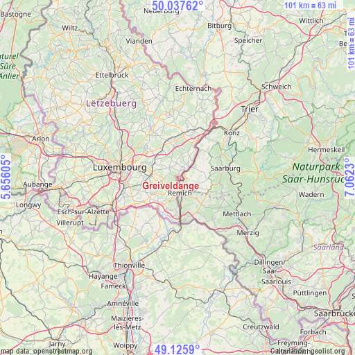
Greiveldange GPS coordinates[2]
49° 35' 2.004" North, 6° 21' 33.012" East
| Map corner | latitude | longitude |
|---|---|---|
| Upper-left | 50.03762°, | 5.65605° |
| Center: | 49.58389°, | 6.35917° |
| Lower-right: | 49.1259°, | 7.0623° |
| Map W x H: | 101.4×101.4 km | = 63×63mi |
| max Lat: | 50.13722° ⇑70.1% North |
| Greiveldange: | 49.58389° |
| min Lat: | ⇓29.9% South 49.45964° |
| min Long | Greiveldange | max Long |
| 5.76583° | 6.35917° | 6.50532° |
| W 89.8%⇐ | ⇒10.2% E |
Elevation
Elevation of Greiveldange is 178 m = 584 ft, and this is 104 m = 341 ft below average elevation for this country.
| Max E: |
502 m = 1647 ft | 92.7% |
| Avg. | 282 m = 925 ft | |
| Greiveldange | 178 m = 584 ft | |
Min E: |
143 m = 469 ft | 7.3% |
See also: Luxembourg elevation on elevation.city.
Geographical zone
Greiveldange is located in North temperate zone (between Tropic of Cancer and the Arctic Circle). Distance of this North polar circle is 1888 km =1173.1 mi to North.| Distance of | km | miles | from Greiveldange |
|---|---|---|---|
| North Pole | 4493.9 | 2792.4 | to North |
| Arctic Circle | 1888 | 1173.1 | to North |
| Tropic Cancer | 2907.3 | 1806.5 | to South |
| Equator | 5513.2 | 3425.7 | to South |


Nearby cities:
15 places around Greiveldange: (largest is in red/bold)
• Bech-Kleinmacher
5.9 km =3.7 mi,  182°
182°
• Bous
4 km =2.5 mi,  212°
212°
• Canach
3.5 km =2.2 mi,  316°
316°
• Dalheim
8.6 km =5.3 mi,  236°
236°
• Ehnen
2.8 km =1.7 mi,  45°
45°
• Lenningen
1.9 km =1.2 mi,  17°
17°
• Moutfort
7.5 km =4.7 mi,  271°
271°
• Oetrange
7.3 km =4.5 mi,  281°
281°
• Remich
4.4 km =2.7 mi,  172°
172°
• Schrassig
7.8 km =4.8 mi,  292°
292°
• Schuttrange
7.7 km =4.8 mi,  301°
301°
• Stadtbredimus
2.4 km =1.5 mi, 170°
• Uebersyren
8 km =5 mi,  312°
312°
• Waldbredimus
6 km =3.7 mi, 239°
• Wormeldange
4.5 km =2.8 mi, 47°
Sources, notices
• [Note1] Compared only with cities in Luxembourg existing in our database
• [Src1] Map data: © OpenStreetMap contributors (CC-BY-SA)
• [Src2] Other city data from geonames.org with taken over terms of usage.
• [Src3] Geographical zone / Annual Mean Temperature by Robert A. Rohde @ Wikipedia
