Uebersyren geodata
Uebersyren (Luxembourg) is a populated place; located in Luxembourg in Europe/Luxembourg (GMT+2) time zone. With population of 616 people, there are 132 cities with bigger population in this country. Compared to other cities in Luxembourg, 58.8% of cities are located further ↑North; 80.8% of cities are located further ←West and 67.2% of cities have higher elevation than Uebersyren. Note1


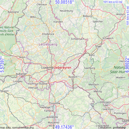
Uebersyren GPS coordinates[2]
49° 37' 54.84" North, 6° 16' 37.56" East
| Map corner | latitude | longitude |
|---|---|---|
| Upper-left | 50.08518°, | 5.57397° |
| Center: | 49.6319°, | 6.2771° |
| Lower-right: | 49.17436°, | 6.98022° |
| Map W x H: | 101.3×101.3 km | = 62.9×62.9mi |
| max Lat: | 50.13722° ⇑58.8% North |
| Uebersyren: | 49.6319° |
| min Lat: | ⇓41.2% South 49.45964° |
| min Long | Uebersyren | max Long |
| 5.76583° | 6.2771° | 6.50532° |
| W 80.8%⇐ | ⇒19.2% E |
Elevation
Elevation of Uebersyren is 258 m = 846 ft, and this is 24 m = 79 ft below average elevation for this country.
| Max E: |
502 m = 1647 ft | 67.2% |
| Avg. | 282 m = 925 ft | |
| Uebersyren | 258 m = 846 ft | |
Min E: |
143 m = 469 ft | 32.8% |
See also: Luxembourg elevation on elevation.city.
Geographical zone
Uebersyren is located in North temperate zone (between Tropic of Cancer and the Arctic Circle). Distance of this North polar circle is 1882.6 km =1169.8 mi to North.| Distance of | km | miles | from Uebersyren |
|---|---|---|---|
| North Pole | 4488.5 | 2789 | to North |
| Arctic Circle | 1882.6 | 1169.8 | to North |
| Tropic Cancer | 2912.6 | 1809.8 | to South |
| Equator | 5518.5 | 3429 | to South |


Nearby cities:
15 places around Uebersyren: (largest is in red/bold)
• Canach
4.5 km =2.8 mi,  128°
128°
• Contern
6.6 km =4.1 mi,  213°
213°
• Flaxweiler
6.1 km =3.8 mi,  51°
51°
• Lenningen
7.4 km =4.6 mi,  118°
118°
• Mensdorf
3.2 km =2 mi,  37°
37°
• Moutfort
5.4 km =3.4 mi,  196°
196°
• Münsbach
0.9 km =0.6 mi,  276°
276°
• Niederanven
2.5 km =1.6 mi,  333°
333°
• Oberanven
3.8 km =2.4 mi,  319°
319°
• Oetrange
4.1 km =2.5 mi, 197°
• Rameldange
4.5 km =2.8 mi,  314°
314°
• Roodt-sur-Syre
4.2 km =2.6 mi,  25°
25°
• Sandweiler
4.4 km =2.7 mi,  244°
244°
• Schrassig
2.7 km =1.7 mi, 208°
• Schuttrange
1.4 km =0.9 mi, 205°
Sources, notices
• [Note1] Compared only with cities in Luxembourg existing in our database
• [Src1] Map data: © OpenStreetMap contributors (CC-BY-SA)
• [Src2] Other city data from geonames.org with taken over terms of usage.
• [Src3] Geographical zone / Annual Mean Temperature by Robert A. Rohde @ Wikipedia
