Canach geodata
Canach (Remich) is a populated place; located in Luxembourg in Europe/Luxembourg (GMT+2) time zone. With population of 955 people, there are 87 cities with bigger population in this country. Compared to other cities in Luxembourg, 65.5% of cities are located further ↑North; 85.3% of cities are located further ←West and 63.3% of cities have higher elevation than Canach. Note1


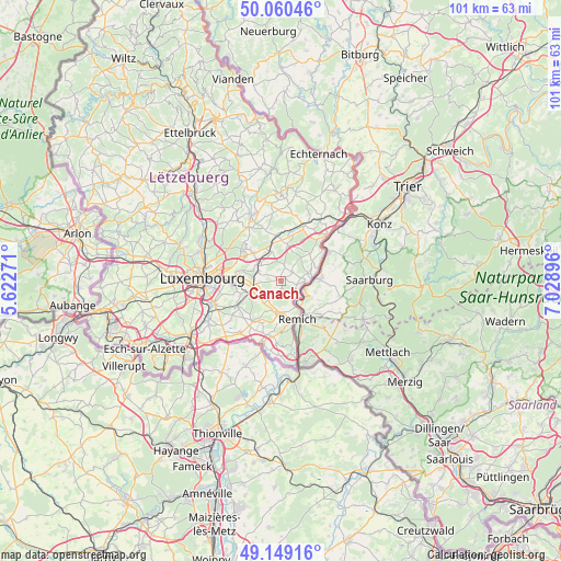
Canach GPS coordinates[2]
49° 36' 24.984" North, 6° 19' 32.988" East
| Map corner | latitude | longitude |
|---|---|---|
| Upper-left | 50.06046°, | 5.62271° |
| Center: | 49.60694°, | 6.32583° |
| Lower-right: | 49.14916°, | 7.02896° |
| Map W x H: | 101.3×101.3 km | = 62.9×62.9mi |
| max Lat: | 50.13722° ⇑65.5% North |
| Canach: | 49.60694° |
| min Lat: | ⇓34.5% South 49.45964° |
| min Long | Canach | max Long |
| 5.76583° | 6.32583° | 6.50532° |
| W 85.3%⇐ | ⇒14.7% E |
Elevation
Elevation of Canach is 263 m = 863 ft, and this is 19 m = 62 ft below average elevation for this country.
| Max E: |
502 m = 1647 ft | 63.3% |
| Avg. | 282 m = 925 ft | |
| Canach | 263 m = 863 ft | |
Min E: |
143 m = 469 ft | 36.7% |
See also: Luxembourg elevation on elevation.city.
Geographical zone
Canach is located in North temperate zone (between Tropic of Cancer and the Arctic Circle). Distance of this North polar circle is 1885.4 km =1171.5 mi to North.| Distance of | km | miles | from Canach |
|---|---|---|---|
| North Pole | 4491.3 | 2790.8 | to North |
| Arctic Circle | 1885.4 | 1171.5 | to North |
| Tropic Cancer | 2909.9 | 1808.1 | to South |
| Equator | 5515.8 | 3427.4 | to South |


Nearby cities:
15 places around Canach: (largest is in red/bold)
• Bous
5.9 km =3.7 mi,  177°
177°
• Ehnen
4.4 km =2.7 mi,  97°
97°
• Flaxweiler
6.7 km =4.2 mi,  10°
10°
• Greiveldange
3.5 km =2.2 mi,  136°
136°
• Lenningen
3.1 km =1.9 mi, 103°
• Mensdorf
5.5 km =3.4 mi,  343°
343°
• Moutfort
5.6 km =3.5 mi,  244°
244°
• Münsbach
5.3 km =3.3 mi,  303°
303°
• Oetrange
4.9 km =3 mi,  256°
256°
• Schrassig
4.8 km =3 mi,  274°
274°
• Schuttrange
4.4 km =2.7 mi,  290°
290°
• Stadtbredimus
5.6 km =3.5 mi,  150°
150°
• Uebersyren
4.5 km =2.8 mi,  308°
308°
• Waldbredimus
6.2 km =3.9 mi,  206°
206°
• Wormeldange
5.8 km =3.6 mi,  85°
85°
Sources, notices
• [Note1] Compared only with cities in Luxembourg existing in our database
• [Src1] Map data: © OpenStreetMap contributors (CC-BY-SA)
• [Src2] Other city data from geonames.org with taken over terms of usage.
• [Src3] Geographical zone / Annual Mean Temperature by Robert A. Rohde @ Wikipedia
