Moutfort geodata
Moutfort (Luxembourg) is a populated place; located in Luxembourg in Europe/Luxembourg (GMT+2) time zone. With population of 1,171 people, there are 68 cities with bigger population in this country. Compared to other cities in Luxembourg, 69.5% of cities are located further ↑North; 75.7% of cities are located further ←West and 67.8% of cities have higher elevation than Moutfort. Note1


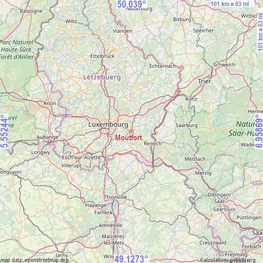
Moutfort GPS coordinates[2]
49° 35' 7.008" North, 6° 15' 20.016" East
| Map corner | latitude | longitude |
|---|---|---|
| Upper-left | 50.039°, | 5.55244° |
| Center: | 49.58528°, | 6.25556° |
| Lower-right: | 49.1273°, | 6.95869° |
| Map W x H: | 101.4×101.4 km | = 63×63mi |
| max Lat: | 50.13722° ⇑69.5% North |
| Moutfort: | 49.58528° |
| min Lat: | ⇓30.5% South 49.45964° |
| min Long | Moutfort | max Long |
| 5.76583° | 6.25556° | 6.50532° |
| W 75.7%⇐ | ⇒24.3% E |
Elevation
Elevation of Moutfort is 257 m = 843 ft, and this is 25 m = 82 ft below average elevation for this country.
| Max E: |
502 m = 1647 ft | 67.8% |
| Avg. | 282 m = 925 ft | |
| Moutfort | 257 m = 843 ft | |
Min E: |
143 m = 469 ft | 32.2% |
See also: Luxembourg elevation on elevation.city.
Geographical zone
Moutfort is located in North temperate zone (between Tropic of Cancer and the Arctic Circle). Distance of this North polar circle is 1887.8 km =1173 mi to North.| Distance of | km | miles | from Moutfort |
|---|---|---|---|
| North Pole | 4493.7 | 2792.3 | to North |
| Arctic Circle | 1887.8 | 1173 | to North |
| Tropic Cancer | 2907.4 | 1806.6 | to South |
| Equator | 5513.4 | 3425.9 | to South |


Nearby cities:
15 places around Moutfort: (largest is in red/bold)
• Alzingen
7 km =4.3 mi,  251°
251°
• Aspelt
7.3 km =4.5 mi,  197°
197°
• Bous
6.4 km =4 mi,  123°
123°
• Canach
5.6 km =3.5 mi,  64°
64°
• Contern
2.1 km =1.3 mi,  259°
259°
• Dalheim
5 km =3.1 mi,  176°
176°
• Itzig
6.1 km =3.8 mi,  272°
272°
• Münsbach
5.3 km =3.3 mi,  7°
7°
• Oetrange
1.3 km =0.8 mi, 14°
• Sandweiler
4.1 km =2.5 mi,  323°
323°
• Schrassig
2.8 km =1.7 mi, 5°
• Schuttrange
4 km =2.5 mi, 13°
• Uebersyren
5.4 km =3.4 mi,  16°
16°
• Waldbredimus
3.9 km =2.4 mi,  143°
143°
• Weiler-la-Tour
6.3 km =3.9 mi,  218°
218°
Sources, notices
• [Note1] Compared only with cities in Luxembourg existing in our database
• [Src1] Map data: © OpenStreetMap contributors (CC-BY-SA)
• [Src2] Other city data from geonames.org with taken over terms of usage.
• [Src3] Geographical zone / Annual Mean Temperature by Robert A. Rohde @ Wikipedia
