Schuttrange geodata
Schuttrange (Luxembourg) is a seat of a third-order administrative division; located in Luxembourg in Europe/Luxembourg (GMT+2) time zone. With population of 841 people, there are 94 cities with bigger population in this country. Compared to other cities in Luxembourg, 61% of cities are located further ↑North; 80.2% of cities are located further ←West and 72.3% of cities have higher elevation than Schuttrange. Note1


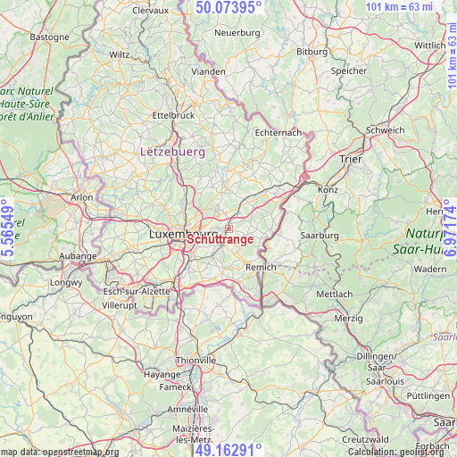
Schuttrange GPS coordinates[2]
49° 37' 14.016" North, 6° 16' 6.996" East
| Map corner | latitude | longitude |
|---|---|---|
| Upper-left | 50.07395°, | 5.56549° |
| Center: | 49.62056°, | 6.26861° |
| Lower-right: | 49.16291°, | 6.97174° |
| Map W x H: | 101.3×101.3 km | = 62.9×62.9mi |
| max Lat: | 50.13722° ⇑61% North |
| Schuttrange: | 49.62056° |
| min Lat: | ⇓39% South 49.45964° |
| min Long | Schuttrange | max Long |
| 5.76583° | 6.26861° | 6.50532° |
| W 80.2%⇐ | ⇒19.8% E |
Elevation
Elevation of Schuttrange is 246 m = 807 ft, and this is 36 m = 118 ft below average elevation for this country.
| Max E: |
502 m = 1647 ft | 72.3% |
| Avg. | 282 m = 925 ft | |
| Schuttrange | 246 m = 807 ft | |
Min E: |
143 m = 469 ft | 27.7% |
See also: Luxembourg elevation on elevation.city.
Geographical zone
Schuttrange is located in North temperate zone (between Tropic of Cancer and the Arctic Circle). Distance of this North polar circle is 1883.9 km =1170.6 mi to North.| Distance of | km | miles | from Schuttrange |
|---|---|---|---|
| North Pole | 4489.8 | 2789.8 | to North |
| Arctic Circle | 1883.9 | 1170.6 | to North |
| Tropic Cancer | 2911.4 | 1809.1 | to South |
| Equator | 5517.3 | 3428.3 | to South |


Nearby cities:
15 places around Schuttrange: (largest is in red/bold)
• Canach
4.4 km =2.7 mi,  110°
110°
• Contern
5.3 km =3.3 mi,  215°
215°
• Flaxweiler
7.4 km =4.6 mi,  46°
46°
• Mensdorf
4.6 km =2.9 mi,  34°
34°
• Moutfort
4 km =2.5 mi,  193°
193°
• Münsbach
1.4 km =0.9 mi,  347°
347°
• Niederanven
3.5 km =2.2 mi, 352°
• Oberanven
4.5 km =2.8 mi,  335°
335°
• Oetrange
2.8 km =1.7 mi, 192°
• Rameldange
5.1 km =3.2 mi,  329°
329°
• Roodt-sur-Syre
5.6 km =3.5 mi, 25°
• Sandweiler
3.4 km =2.1 mi,  258°
258°
• Schrassig
1.3 km =0.8 mi,  210°
210°
• Uebersyren
1.4 km =0.9 mi, 25°
• Waldbredimus
7.2 km =4.5 mi,  168°
168°
Sources, notices
• [Note1] Compared only with cities in Luxembourg existing in our database
• [Src1] Map data: © OpenStreetMap contributors (CC-BY-SA)
• [Src2] Other city data from geonames.org with taken over terms of usage.
• [Src3] Geographical zone / Annual Mean Temperature by Robert A. Rohde @ Wikipedia
