Mertzig geodata
Mertzig (Diekirch) is a seat of a third-order administrative division; located in Luxembourg in Europe/Luxembourg (GMT+2) time zone. With population of 1,482 people, there are 52 cities with bigger population in this country. Compared to other cities in Luxembourg, 84.7% of cities are located further ↓South; 71.2% of cities are located further →East and 72.9% of cities have lower elevation than Mertzig. Note1


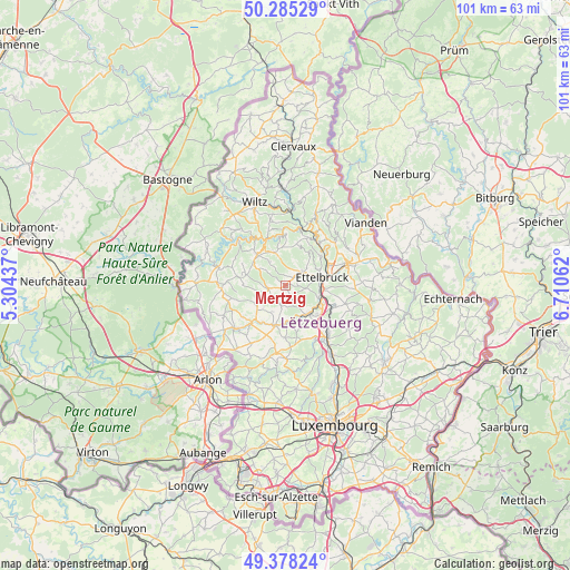
Mertzig GPS coordinates[2]
49° 50' 2.004" North, 6° 0' 27" East
| Map corner | latitude | longitude |
|---|---|---|
| Upper-left | 50.28529°, | 5.30437° |
| Center: | 49.83389°, | 6.0075° |
| Lower-right: | 49.37824°, | 6.71062° |
| Map W x H: | 100.9×100.9 km | = 62.7×62.7mi |
| max Lat: | 50.13722° ⇑15.3% North |
| Mertzig: | 49.83389° |
| min Lat: | ⇓84.7% South 49.45964° |
| min Long | Mertzig | max Long |
| 5.76583° | 6.0075° | 6.50532° |
| W 28.8%⇐ | ⇒71.2% E |
Elevation
Elevation of Mertzig is 312 m = 1024 ft, and this is 30 m = 98 ft above average elevation for this country.
| Max E: |
502 m = 1647 ft | 27.1% |
| Mertzig | 312 m 1024 ft | |
| Avg. | 282 m = 925 ft | |
Min E: |
143 m = 469 ft | 72.9% |
See also: Luxembourg elevation on elevation.city.
Geographical zone
Mertzig is located in North temperate zone (between Tropic of Cancer and the Arctic Circle). Distance of this North polar circle is 1860.2 km =1155.9 mi to North.| Distance of | km | miles | from Mertzig |
|---|---|---|---|
| North Pole | 4466.1 | 2775.1 | to North |
| Arctic Circle | 1860.2 | 1155.9 | to North |
| Tropic Cancer | 2935.1 | 1823.8 | to South |
| Equator | 5541 | 3443 | to South |


Nearby cities:
15 places around Mertzig: (largest is in red/bold)
• Bettborn
6.4 km =4 mi,  227°
227°
• Bissen
6.6 km =4.1 mi,  141°
141°
• Boevange-sur-Attert
6.8 km =4.2 mi,  175°
175°
• Colmar
7 km =4.3 mi,  112°
112°
• Erpeldange
8.4 km =5.2 mi,  65°
65°
• Ettelbruck
7.1 km =4.4 mi,  77°
77°
• Grosbous
3 km =1.9 mi,  256°
256°
• Ingeldorf
9.3 km =5.8 mi, 77°
• Niederfeulen
3.7 km =2.3 mi,  49°
49°
• Platen
7.2 km =4.5 mi, 226°
• Schieren
6.5 km =4 mi,  93°
93°
• Useldange
7.4 km =4.6 mi,  194°
194°
• Vichten
3.5 km =2.2 mi, 188°
• Wahl
7.3 km =4.5 mi,  272°
272°
• Warken
6.2 km =3.9 mi,  62°
62°
Sources, notices
• [Note1] Compared only with cities in Luxembourg existing in our database
• [Src1] Map data: © OpenStreetMap contributors (CC-BY-SA)
• [Src2] Other city data from geonames.org with taken over terms of usage.
• [Src3] Geographical zone / Annual Mean Temperature by Robert A. Rohde @ Wikipedia
