Ventspils geodata
Ventspils is a seat of a first-order administrative division; located in Latvia in Europe/Riga (GMT+3) time zone. With population of 42,644 people, there are 5 cities with bigger population in this country. Compared to other cities in Latvia, 85.7% of cities are located further ↓South; 94.3% of cities are located further →East and 89.3% of cities have higher elevation than Ventspils. Note1


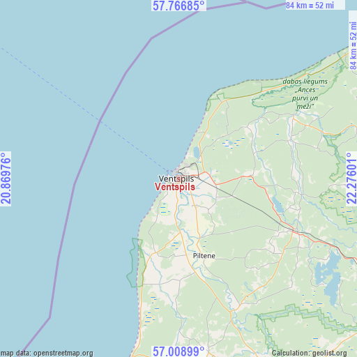
Ventspils GPS coordinates[2]
57° 23' 23.568" North, 21° 34' 22.368" East
| Map corner | latitude | longitude |
|---|---|---|
| Upper-left | 57.76685°, | 20.86976° |
| Center: | 57.38988°, | 21.57288° |
| Lower-right: | 57.00899°, | 22.27601° |
| Map W x H: | 84.3×84.3 km | = 52.4×52.4mi |
| max Lat: | 57.89752° ⇑14.3% North |
| Ventspils: | 57.38988° |
| min Lat: | ⇓85.7% South 55.75284° |
| min Long | Ventspils | max Long |
| 21.01085° | 21.57288° | 28.12165° |
| W 5.7%⇐ | ⇒94.3% E |
Elevation
Elevation of Ventspils is 7 m = 23 ft, and this is 58.4 m = 192 ft below average elevation for this country.
| Max E: |
212 m = 696 ft | 89.3% |
| Avg. | 65.4 m = 215 ft | |
| Ventspils | 7 m = 23 ft | |
Min E: |
2 m = 7 ft | 10.7% |
See also: Ventspils elevation on elevation.city.
Geographical zone
Ventspils is located in North temperate zone (between Tropic of Cancer and the Arctic Circle). Distance of this North polar circle is 1020 km =633.8 mi to North.| Distance of | km | miles | from Ventspils |
|---|---|---|---|
| North Pole | 3625.9 | 2253 | to North |
| Arctic Circle | 1020 | 633.8 | to North |
| Tropic Cancer | 3775.2 | 2345.8 | to South |
| Equator | 6381.2 | 3965.1 | to South |


Nearby cities:
15 places around Ventspils: (largest is in red/bold)
• Aizpute
74.4 km =46.2 mi,  178°
178°
• Alsunga
45.4 km =28.2 mi, 181°
• Dundaga
48.2 km =30 mi,  74°
74°
• Kandava
82.1 km =51 mi,  118°
118°
• Kuldīga
51.7 km =32.1 mi,  153°
153°
• Lieģi
91 km =56.5 mi,  189°
189°
• Piltene
19.4 km =12.1 mi,  161°
161°
• Pāvilosta
60.5 km =37.6 mi,  202°
202°
• Roja
75 km =46.6 mi,  80°
80°
• Sabile
71.3 km =44.3 mi, 122°
• Skrunda
83.6 km =51.9 mi, 161°
• Stende
63.9 km =39.7 mi, 115°
• Talsi
62.6 km =38.9 mi,  104°
104°
• Valdemārpils
61.1 km =38 mi,  92°
92°
• Ēdole
41.7 km =25.9 mi,  170°
170°
Sources, notices
• [Note1] Compared only with cities in Latvia existing in our database
• [Src1] Map data: © OpenStreetMap contributors (CC-BY-SA)
• [Src2] Other city data from geonames.org with taken over terms of usage.
• [Src3] Geographical zone / Annual Mean Temperature by Robert A. Rohde @ Wikipedia
