Valdemārpils geodata
Valdemārpils (Talsi Municipality) is a populated place; located in Latvia in Europe/Riga (GMT+3) time zone. With population of 1,447 people, there are 89 cities with bigger population in this country. Compared to other cities in Latvia, 85% of cities are located further ↓South; 84.3% of cities are located further →East and 50.7% of cities have higher elevation than Valdemārpils. Note1


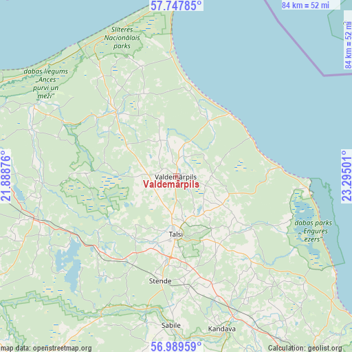
Valdemārpils GPS coordinates[2]
57° 22' 14.448" North, 22° 35' 30.768" East
| Map corner | latitude | longitude |
|---|---|---|
| Upper-left | 57.74785°, | 21.88876° |
| Center: | 57.37068°, | 22.59188° |
| Lower-right: | 56.98959°, | 23.29501° |
| Map W x H: | 84.3×84.3 km | = 52.4×52.4mi |
| max Lat: | 57.89752° ⇑15% North |
| Valdemārpils: | 57.37068° |
| min Lat: | ⇓85% South 55.75284° |
| min Long | Valdemārpils | max Long |
| 21.01085° | 22.59188° | 28.12165° |
| W 15.7%⇐ | ⇒84.3% E |
Elevation
Elevation of Valdemārpils is 56 m = 184 ft, and this is 9.4 m = 31 ft below average elevation for this country.
| Max E: |
212 m = 696 ft | 50.7% |
| Avg. | 65.4 m = 215 ft | |
| Valdemārpils | 56 m = 184 ft | |
Min E: |
2 m = 7 ft | 49.3% |
See also: Latvia elevation on elevation.city.
Geographical zone
Valdemārpils is located in North temperate zone (between Tropic of Cancer and the Arctic Circle). Distance of this North polar circle is 1022.2 km =635.2 mi to North.| Distance of | km | miles | from Valdemārpils |
|---|---|---|---|
| North Pole | 3628 | 2254.3 | to North |
| Arctic Circle | 1022.2 | 635.2 | to North |
| Tropic Cancer | 3773.1 | 2344.5 | to South |
| Equator | 6379 | 3963.7 | to South |


Nearby cities:
15 places around Valdemārpils: (largest is in red/bold)
• Dundaga
20.8 km =12.9 mi,  315°
315°
• Engure
44.7 km =27.8 mi,  121°
121°
• Kandava
38.3 km =23.8 mi,  163°
163°
• Kuldīga
58.4 km =36.3 mi,  220°
220°
• Milzkalne
58.1 km =36.1 mi,  138°
138°
• Mērsrags
32.2 km =20 mi,  97°
97°
• Piltene
57.5 km =35.7 mi,  253°
253°
• Ragaciems
66.8 km =41.5 mi,  125°
125°
• Roja
19.5 km =12.1 mi,  41°
41°
• Sabile
36.1 km =22.4 mi,  181°
181°
• Smārde
64.5 km =40.1 mi, 135°
• Stende
25.3 km =15.7 mi,  187°
187°
• Talsi
13.9 km =8.6 mi, 182°
• Tukums
56.2 km =34.9 mi, 142°
• Ventspils
61.1 km =38 mi,  272°
272°
Sources, notices
• [Note1] Compared only with cities in Latvia existing in our database
• [Src1] Map data: © OpenStreetMap contributors (CC-BY-SA)
• [Src2] Other city data from geonames.org with taken over terms of usage.
• [Src3] Geographical zone / Annual Mean Temperature by Robert A. Rohde @ Wikipedia
