Dundaga geodata
Dundaga is a seat of a first-order administrative division; located in Latvia in Europe/Riga (GMT+3) time zone. In our database, there are 110 cities with bigger population. Compared to other cities in Latvia, 89.3% of cities are located further ↓South; 88.6% of cities are located further →East and 54.3% of cities have lower elevation than Dundaga. Note1


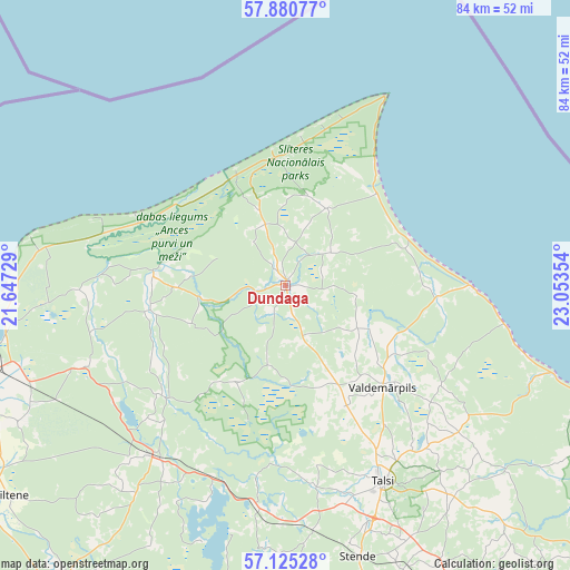
Dundaga GPS coordinates[2]
57° 30' 17.928" North, 22° 21' 1.476" East
| Map corner | latitude | longitude |
|---|---|---|
| Upper-left | 57.88077°, | 21.64729° |
| Center: | 57.50498°, | 22.35041° |
| Lower-right: | 57.12528°, | 23.05354° |
| Map W x H: | 84×84 km | = 52.2×52.2mi |
| max Lat: | 57.89752° ⇑10.7% North |
| Dundaga: | 57.50498° |
| min Lat: | ⇓89.3% South 55.75284° |
| min Long | Dundaga | max Long |
| 21.01085° | 22.35041° | 28.12165° |
| W 11.4%⇐ | ⇒88.6% E |
Elevation
Elevation of Dundaga is 63 m = 207 ft, and this is 2.4 m = 8 ft below average elevation for this country.
| Max E: |
212 m = 696 ft | 45.7% |
| Avg. | 65.4 m = 215 ft | |
| Dundaga | 63 m = 207 ft | |
Min E: |
2 m = 7 ft | 54.3% |
See also: Latvia elevation on elevation.city.
Geographical zone
Dundaga is located in North temperate zone (between Tropic of Cancer and the Arctic Circle). Distance of this North polar circle is 1007.2 km =625.8 mi to North.| Distance of | km | miles | from Dundaga |
|---|---|---|---|
| North Pole | 3613.1 | 2245.1 | to North |
| Arctic Circle | 1007.2 | 625.8 | to North |
| Tropic Cancer | 3788 | 2353.8 | to South |
| Equator | 6394 | 3973 | to South |


Nearby cities:
15 places around Dundaga: (largest is in red/bold)
• Alsunga
75.1 km =46.7 mi,  219°
219°
• Engure
65 km =40.4 mi,  126°
126°
• Kandava
57.6 km =35.8 mi,  153°
153°
• Kuldīga
63.6 km =39.5 mi,  201°
201°
• Milzkalne
78.8 km =49 mi,  138°
138°
• Mērsrags
50 km =31.1 mi,  112°
112°
• Piltene
51.2 km =31.8 mi,  232°
232°
• Roja
27.4 km =17 mi,  90°
90°
• Sabile
52.8 km =32.8 mi,  165°
165°
• Stende
41.5 km =25.8 mi,  164°
164°
• Talsi
32 km =19.9 mi, 154°
• Tukums
76.9 km =47.8 mi, 140°
• Valdemārpils
20.8 km =12.9 mi, 135°
• Ventspils
48.2 km =30 mi,  254°
254°
• Ēdole
66.9 km =41.6 mi, 216°
Sources, notices
• [Note1] Compared only with cities in Latvia existing in our database
• [Src1] Map data: © OpenStreetMap contributors (CC-BY-SA)
• [Src2] Other city data from geonames.org with taken over terms of usage.
• [Src3] Geographical zone / Annual Mean Temperature by Robert A. Rohde @ Wikipedia
