Sigulda geodata
Sigulda is a seat of a first-order administrative division; located in Latvia in Europe/Riga (GMT+3) time zone. With population of 10,422 people, there are 22 cities with bigger population in this country. Compared to other cities in Latvia, 73.6% of cities are located further ↓South; 55% of cities are located further ←West and 77.9% of cities have lower elevation than Sigulda. Note1


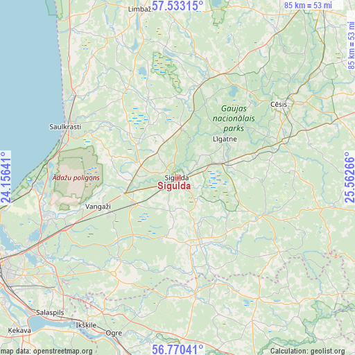
Sigulda GPS coordinates[2]
57° 9' 13.5" North, 24° 51' 34.308" East
| Map corner | latitude | longitude |
|---|---|---|
| Upper-left | 57.53315°, | 24.15641° |
| Center: | 57.15375°, | 24.85953° |
| Lower-right: | 56.77041°, | 25.56266° |
| Map W x H: | 84.8×84.8 km | = 52.7×52.7mi |
| max Lat: | 57.89752° ⇑26.4% North |
| Sigulda: | 57.15375° |
| min Lat: | ⇓73.6% South 55.75284° |
| min Long | Sigulda | max Long |
| 21.01085° | 24.85953° | 28.12165° |
| W 55%⇐ | ⇒45% E |
Elevation
Elevation of Sigulda is 101 m = 331 ft, and this is 35.6 m = 117 ft above average elevation for this country.
| Max E: |
212 m = 696 ft | 22.1% |
| Sigulda | 101 m 331 ft | |
| Avg. | 65.4 m = 215 ft | |
Min E: |
2 m = 7 ft | 77.9% |
See also: Latvia elevation on elevation.city.
Geographical zone
Sigulda is located in North temperate zone (between Tropic of Cancer and the Arctic Circle). Distance of this North polar circle is 1046.3 km =650.1 mi to North.| Distance of | km | miles | from Sigulda |
|---|---|---|---|
| North Pole | 3652.2 | 2269.4 | to North |
| Arctic Circle | 1046.3 | 650.1 | to North |
| Tropic Cancer | 3749 | 2329.5 | to South |
| Equator | 6354.9 | 3948.8 | to South |


Nearby cities:
15 places around Sigulda: (largest is in red/bold)
• Carnikava
34.8 km =21.6 mi,  265°
265°
• Cēsis
30.5 km =19 mi,  54°
54°
• Drabeši
27.1 km =16.8 mi,  68°
68°
• Garkalne
29.2 km =18.1 mi,  245°
245°
• Inčukalns
12.1 km =7.5 mi,  239°
239°
• Loja
13 km =8.1 mi, 269°
• Līgatne
14.1 km =8.8 mi, 50°
• Mālpils
17 km =10.6 mi,  159°
159°
• Priekuļi
35.1 km =21.8 mi,  59°
59°
• Ragana
9.7 km =6 mi,  288°
288°
• Ropaži
24.2 km =15 mi,  214°
214°
• Saulkrasti
29.4 km =18.3 mi, 294°
• Stalbe
26.2 km =16.3 mi,  23°
23°
• Vangaži
20.1 km =12.5 mi, 250°
• Ādaži
32.9 km =20.4 mi, 253°
Sources, notices
• [Note1] Compared only with cities in Latvia existing in our database
• [Src1] Map data: © OpenStreetMap contributors (CC-BY-SA)
• [Src2] Other city data from geonames.org with taken over terms of usage.
• [Src3] Geographical zone / Annual Mean Temperature by Robert A. Rohde @ Wikipedia
