Inčukalns geodata
Inčukalns is a seat of a first-order administrative division; located in Latvia in Europe/Riga (GMT+3) time zone. With population of 2,028 people, there are 73 cities with bigger population in this country. Compared to other cities in Latvia, 70% of cities are located further ↓South; 50.7% of cities are located further ←West and 52.1% of cities have higher elevation than Inčukalns. Note1


Inčukalns GPS coordinates[2]
57° 5' 55.212" North, 24° 41' 10.68" East
| Map corner | latitude | longitude |
|---|---|---|
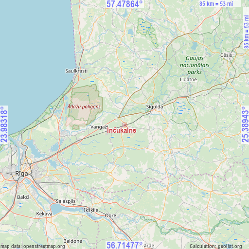
| Upper-left | 57.47864°, | 23.98318° |
| Center: | 57.09867°, | 24.6863° |
| Lower-right: | 56.71477°, | 25.38943° |
| Map W x H: | 84.9×84.9 km | = 52.8×52.8mi |
| max Lat: | 57.89752° ⇑30% North |
| Inčukalns: | 57.09867° |
| min Lat: | ⇓70% South 55.75284° |
| min Long | Inčukalns | max Long |
| 21.01085° | 24.6863° | 28.12165° |
| W 50.7%⇐ | ⇒49.3% E |
Elevation
Elevation of Inčukalns is 55 m = 180 ft, and this is 10.4 m = 34 ft below average elevation for this country.
| Max E: |
212 m = 696 ft | 52.1% |
| Avg. | 65.4 m = 215 ft | |
| Inčukalns | 55 m = 180 ft | |
Min E: |
2 m = 7 ft | 47.9% |
See also: Latvia elevation on elevation.city.
Geographical zone
Inčukalns is located in North temperate zone (between Tropic of Cancer and the Arctic Circle). Distance of this North polar circle is 1052.4 km =653.9 mi to North.| Distance of | km | miles | from Inčukalns |
|---|---|---|---|
| North Pole | 3658.3 | 2273.2 | to North |
| Arctic Circle | 1052.4 | 653.9 | to North |
| Tropic Cancer | 3742.9 | 2325.7 | to South |
| Equator | 6348.8 | 3945 | to South |


Nearby cities:
15 places around Inčukalns: (largest is in red/bold)
• Berģi
26.5 km =16.5 mi,  241°
241°
• Carnikava
24.5 km =15.2 mi,  277°
277°
• Garkalne
17.2 km =10.7 mi,  249°
249°
• Ikšķile
31.6 km =19.6 mi,  201°
201°
• Loja
6.6 km =4.1 mi,  336°
336°
• Līgatne
26.1 km =16.2 mi,  54°
54°
• Mālpils
19.1 km =11.9 mi,  120°
120°
• Ogre
31.7 km =19.7 mi,  187°
187°
• Ragana
9.2 km =5.7 mi,  7°
7°
• Ropaži
14.2 km =8.8 mi, 193°
• Saulkrasti
24.5 km =15.2 mi,  318°
318°
• Sigulda
12.1 km =7.5 mi,  59°
59°
• Ulbroka
29.4 km =18.3 mi,  232°
232°
• Vangaži
8.6 km =5.3 mi,  266°
266°
• Ādaži
21.3 km =13.2 mi,  261°
261°
Sources, notices
• [Note1] Compared only with cities in Latvia existing in our database
• [Src1] Map data: © OpenStreetMap contributors (CC-BY-SA)
• [Src2] Other city data from geonames.org with taken over terms of usage.
• [Src3] Geographical zone / Annual Mean Temperature by Robert A. Rohde @ Wikipedia
