Stalbe geodata
Stalbe (Pārgaujas) is a seat of a first-order administrative division; located in Latvia in Europe/Riga (GMT+3) time zone. In our database, there are 110 cities with bigger population. Compared to other cities in Latvia, 84.3% of cities are located further ↓South; 57.9% of cities are located further ←West and 55.7% of cities have lower elevation than Stalbe. Note1


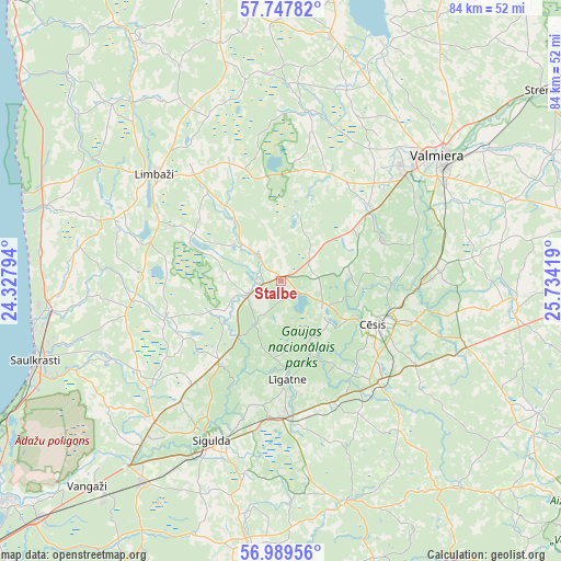
Stalbe GPS coordinates[2]
57° 22' 14.34" North, 25° 1' 51.816" East
| Map corner | latitude | longitude |
|---|---|---|
| Upper-left | 57.74782°, | 24.32794° |
| Center: | 57.37065°, | 25.03106° |
| Lower-right: | 56.98956°, | 25.73419° |
| Map W x H: | 84.3×84.3 km | = 52.4×52.4mi |
| max Lat: | 57.89752° ⇑15.7% North |
| Stalbe: | 57.37065° |
| min Lat: | ⇓84.3% South 55.75284° |
| min Long | Stalbe | max Long |
| 21.01085° | 25.03106° | 28.12165° |
| W 57.9%⇐ | ⇒42.1% E |
Elevation
Elevation of Stalbe is 66 m = 217 ft, and this is 0.59999999999999 m = 2 ft above average elevation for this country.
| Max E: |
212 m = 696 ft | 44.3% |
| Stalbe | 66 m 217 ft | |
| Avg. | 65.4 m = 215 ft | |
Min E: |
2 m = 7 ft | 55.7% |
See also: Latvia elevation on elevation.city.
Geographical zone
Stalbe is located in North temperate zone (between Tropic of Cancer and the Arctic Circle). Distance of this North polar circle is 1022.2 km =635.2 mi to North.| Distance of | km | miles | from Stalbe |
|---|---|---|---|
| North Pole | 3628 | 2254.3 | to North |
| Arctic Circle | 1022.2 | 635.2 | to North |
| Tropic Cancer | 3773.1 | 2344.5 | to South |
| Equator | 6379 | 3963.7 | to South |


Nearby cities:
15 places around Stalbe: (largest is in red/bold)
• Cēsis
16 km =9.9 mi,  114°
114°
• Drabeši
20.5 km =12.7 mi,  133°
133°
• Inčukalns
36.7 km =22.8 mi,  214°
214°
• Kocēni
24.8 km =15.4 mi,  47°
47°
• Limbaži
24.5 km =15.2 mi,  310°
310°
• Loja
33.6 km =20.9 mi,  223°
223°
• Līgatne
15.2 km =9.4 mi,  177°
177°
• Matīši
37.3 km =23.2 mi,  11°
11°
• Mūrmuiža
29.8 km =18.5 mi,  67°
67°
• Priekuļi
20.8 km =12.9 mi, 107°
• Ragana
28.7 km =17.8 mi, 222°
• Rauna
35 km =21.7 mi,  97°
97°
• Saulkrasti
38.9 km =24.2 mi,  251°
251°
• Sigulda
26.2 km =16.3 mi,  203°
203°
• Valmiera
30.4 km =18.9 mi, 51°
Sources, notices
• [Note1] Compared only with cities in Latvia existing in our database
• [Src1] Map data: © OpenStreetMap contributors (CC-BY-SA)
• [Src2] Other city data from geonames.org with taken over terms of usage.
• [Src3] Geographical zone / Annual Mean Temperature by Robert A. Rohde @ Wikipedia
