Līgatne geodata
Līgatne is a seat of a first-order administrative division; located in Latvia in Europe/Riga (GMT+3) time zone. With population of 1,433 people, there are 90 cities with bigger population in this country. Compared to other cities in Latvia, 78.6% of cities are located further ↓South; 58.6% of cities are located further ←West and 50.7% of cities have higher elevation than Līgatne. Note1


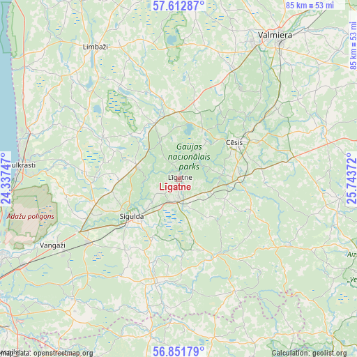
Līgatne GPS coordinates[2]
57° 14' 3.444" North, 25° 2' 26.124" East
| Map corner | latitude | longitude |
|---|---|---|
| Upper-left | 57.61287°, | 24.33747° |
| Center: | 57.23429°, | 25.04059° |
| Lower-right: | 56.85179°, | 25.74372° |
| Map W x H: | 84.6×84.6 km | = 52.6×52.6mi |
| max Lat: | 57.89752° ⇑21.4% North |
| Līgatne: | 57.23429° |
| min Lat: | ⇓78.6% South 55.75284° |
| min Long | Līgatne | max Long |
| 21.01085° | 25.04059° | 28.12165° |
| W 58.6%⇐ | ⇒41.4% E |
Elevation
Elevation of Līgatne is 56 m = 184 ft, and this is 9.4 m = 31 ft below average elevation for this country.
| Max E: |
212 m = 696 ft | 50.7% |
| Avg. | 65.4 m = 215 ft | |
| Līgatne | 56 m = 184 ft | |
Min E: |
2 m = 7 ft | 49.3% |
See also: Latvia elevation on elevation.city.
Geographical zone
Līgatne is located in North temperate zone (between Tropic of Cancer and the Arctic Circle). Distance of this North polar circle is 1037.3 km =644.5 mi to North.| Distance of | km | miles | from Līgatne |
|---|---|---|---|
| North Pole | 3643.2 | 2263.8 | to North |
| Arctic Circle | 1037.3 | 644.5 | to North |
| Tropic Cancer | 3757.9 | 2335.1 | to South |
| Equator | 6363.9 | 3954.3 | to South |


Nearby cities:
15 places around Līgatne: (largest is in red/bold)
• Cēsis
16.5 km =10.3 mi,  58°
58°
• Drabeši
14.3 km =8.9 mi,  86°
86°
• Inčukalns
26.1 km =16.2 mi,  234°
234°
• Kocēni
36.5 km =22.7 mi,  29°
29°
• Limbaži
36.5 km =22.7 mi,  328°
328°
• Loja
25.6 km =15.9 mi,  249°
249°
• Mālpils
25.4 km =15.8 mi,  191°
191°
• Mūrmuiža
37.9 km =23.5 mi,  45°
45°
• Priekuļi
21.3 km =13.2 mi,  65°
65°
• Ragana
20.9 km =13 mi, 253°
• Rauna
35.9 km =22.3 mi, 72°
• Saulkrasti
37.8 km =23.5 mi,  274°
274°
• Sigulda
14.1 km =8.8 mi, 230°
• Stalbe
15.2 km =9.4 mi,  357°
357°
• Vangaži
33.7 km =20.9 mi,  242°
242°
Sources, notices
• [Note1] Compared only with cities in Latvia existing in our database
• [Src1] Map data: © OpenStreetMap contributors (CC-BY-SA)
• [Src2] Other city data from geonames.org with taken over terms of usage.
• [Src3] Geographical zone / Annual Mean Temperature by Robert A. Rohde @ Wikipedia
