Timezgadiouine geodata
Timezgadiouine (Marrakesh-Safi) is a seat of a third-order administrative division; located in Morocco in Africa/Casablanca (GMT+1) time zone. In our database, there are 108 cities with bigger population. Compared to other cities in Morocco, 83.7% of cities are located further ↑North; 88.8% of cities are located further →East and 70.9% of cities have lower elevation than Timezgadiouine. Note1


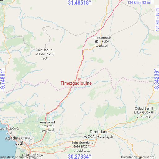
Timezgadiouine GPS coordinates[2]
30° 53' 1.176" North, 9° 2' 43.728" West
| Map corner | latitude | longitude |
|---|---|---|
| Upper-left | 31.48518°, | -9.74861° |
| Center: | 30.88366°, | -9.04548° |
| Lower-right: | 30.27834°, | -8.34236° |
| Map W x H: | 134.2×134.2 km | = 83.4×83.4mi |
| max Lat: | 35.84906° ⇑83.7% North |
| Timezgadiouine: | 30.88366° |
| min Lat: | ⇓16.3% South 22.6558° |
| min Long | Timezgadiouine | max Long |
| -15.60719° | -9.04548° | -1.22855° |
| W 11.2%⇐ | ⇒88.8% E |
Elevation
Elevation of Timezgadiouine is 917 m = 3009 ft, and this is 300.2 m = 985 ft above average elevation for this country.
| Max E: |
2637 m = 8652 ft | 29.1% |
| Timezgadiouine | 917 m 3009 ft | |
| Avg. | 616.8 m = 2024 ft | |
Min E: |
1 m = 3 ft | 70.9% |
See also: Morocco elevation on elevation.city.
Geographical zone
Timezgadiouine is located in North temperate zone (between Tropic of Cancer and the Arctic Circle). Distance of this Northern Tropic circle is 828 km =514.5 mi to South.| Distance of | km | miles | from Timezgadiouine |
|---|---|---|---|
| North Pole | 6573.1 | 4084.3 | to North |
| Arctic Circle | 3967.2 | 2465.1 | to North |
| Tropic Cancer | 828 | 514.5 | to South |
| Equator | 3433.9 | 2133.7 | to South |


Nearby cities:
15 places around Timezgadiouine: (largest is in red/bold)
• Adassil
58.4 km =36.3 mi,  64°
64°
• Aourir
71.2 km =44.2 mi,  232°
232°
• Arazane
59.6 km =37 mi,  135°
135°
• Argana
13.3 km =8.3 mi,  212°
212°
• Bigoudine
23.8 km =14.8 mi,  221°
221°
• Bouabout
44.3 km =27.5 mi,  343°
343°
• Dakhla
71.7 km =44.6 mi, 222°
• Oulad Teïma
56.6 km =35.2 mi,  196°
196°
• Smimou
72.9 km =45.3 mi,  299°
299°
• Tadrart
41.3 km =25.7 mi,  252°
252°
• Tamanar
61.7 km =38.3 mi,  282°
282°
• Taouloukoult
37.8 km =23.5 mi,  355°
355°
• Taroudant
48.7 km =30.3 mi,  160°
160°
• Tazemmourt
56.7 km =35.2 mi, 158°
• Tiout
64.4 km =40 mi,  148°
148°
Sources, notices
• [Note1] Compared only with cities in Morocco existing in our database
• [Src1] Map data: © OpenStreetMap contributors (CC-BY-SA)
• [Src2] Other city data from geonames.org with taken over terms of usage.
• [Src3] Geographical zone / Annual Mean Temperature by Robert A. Rohde @ Wikipedia
