Bigoudine geodata
Bigoudine (Souss-Massa) is a seat of a third-order administrative division; located in Morocco in Africa/Casablanca (GMT+1) time zone. In our database, there are 108 cities with bigger population. Compared to other cities in Morocco, 85.3% of cities are located further ↑North; 91.1% of cities are located further →East and 62.4% of cities have lower elevation than Bigoudine. Note1


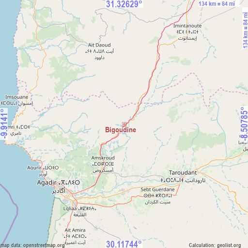
Bigoudine GPS coordinates[2]
30° 43' 25.536" North, 9° 12' 39.492" West
| Map corner | latitude | longitude |
|---|---|---|
| Upper-left | 31.32629°, | -9.9141° |
| Center: | 30.72376°, | -9.21097° |
| Lower-right: | 30.11744°, | -8.50785° |
| Map W x H: | 134.4×134.4 km | = 83.5×83.5mi |
| max Lat: | 35.84906° ⇑85.3% North |
| Bigoudine: | 30.72376° |
| min Lat: | ⇓14.7% South 22.6558° |
| min Long | Bigoudine | max Long |
| -15.60719° | -9.21097° | -1.22855° |
| W 8.9%⇐ | ⇒91.1% E |
Elevation
Elevation of Bigoudine is 741 m = 2431 ft, and this is 124.2 m = 407 ft above average elevation for this country.
| Max E: |
2637 m = 8652 ft | 37.6% |
| Bigoudine | 741 m 2431 ft | |
| Avg. | 616.8 m = 2024 ft | |
Min E: |
1 m = 3 ft | 62.4% |
See also: Morocco elevation on elevation.city.
Geographical zone
Bigoudine is located in North temperate zone (between Tropic of Cancer and the Arctic Circle). Distance of this Northern Tropic circle is 810.2 km =503.4 mi to South.| Distance of | km | miles | from Bigoudine |
|---|---|---|---|
| North Pole | 6590.9 | 4095.4 | to North |
| Arctic Circle | 3985 | 2476.2 | to North |
| Tropic Cancer | 810.2 | 503.4 | to South |
| Equator | 3416.2 | 2122.7 | to South |


Nearby cities:
15 places around Bigoudine: (largest is in red/bold)
• Agadir
50.1 km =31.1 mi,  227°
227°
• Aourir
48.1 km =29.9 mi,  237°
237°
• Argana
10.9 km =6.8 mi,  53°
53°
• Bouabout
60.3 km =37.5 mi,  2°
2°
• Dakhla
48 km =29.8 mi,  223°
223°
• Inezgane
51.5 km =32 mi, 217°
• Oulad Teïma
36.6 km =22.7 mi,  179°
179°
• Tadrart
24.4 km =15.2 mi,  283°
283°
• Taghazout
51.9 km =32.2 mi,  247°
247°
• Tamanar
54.2 km =33.7 mi,  304°
304°
• Tamri
59.2 km =36.8 mi,  267°
267°
• Taouloukoult
56.8 km =35.3 mi,  12°
12°
• Taroudant
42.6 km =26.5 mi,  131°
131°
• Tazemmourt
50.7 km =31.5 mi, 133°
• Timezgadiouine
23.8 km =14.8 mi,  41°
41°
Sources, notices
• [Note1] Compared only with cities in Morocco existing in our database
• [Src1] Map data: © OpenStreetMap contributors (CC-BY-SA)
• [Src2] Other city data from geonames.org with taken over terms of usage.
• [Src3] Geographical zone / Annual Mean Temperature by Robert A. Rohde @ Wikipedia
