Taroudant geodata
Taroudant (Souss-Massa) is a seat of a third-order administrative division; located in Morocco in Africa/Casablanca (GMT+1) time zone. With population of 71,133 people, there are 36 cities with bigger population in this country. Compared to other cities in Morocco, 89.1% of cities are located further ↑North; 87.2% of cities are located further →East and 69.4% of cities have higher elevation than Taroudant. Note1


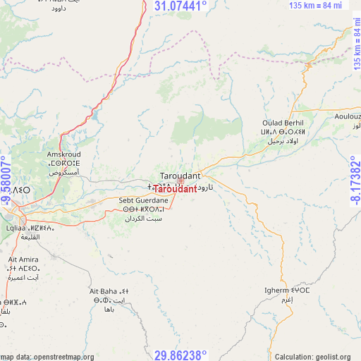
Taroudant GPS coordinates[2]
30° 28' 13.008" North, 8° 52' 37.02" West
| Map corner | latitude | longitude |
|---|---|---|
| Upper-left | 31.07441°, | -9.58007° |
| Center: | 30.47028°, | -8.87695° |
| Lower-right: | 29.86238°, | -8.17382° |
| Map W x H: | 134.8×134.8 km | = 83.8×83.8mi |
| max Lat: | 35.84906° ⇑89.1% North |
| Taroudant: | 30.47028° |
| min Lat: | ⇓10.9% South 22.6558° |
| min Long | Taroudant | max Long |
| -15.60719° | -8.87695° | -1.22855° |
| W 12.8%⇐ | ⇒87.2% E |
Elevation
Elevation of Taroudant is 237 m = 778 ft, and this is 379.8 m = 1246 ft below average elevation for this country.
| Max E: |
2637 m = 8652 ft | 69.4% |
| Avg. | 616.8 m = 2024 ft | |
| Taroudant | 237 m = 778 ft | |
Min E: |
1 m = 3 ft | 30.6% |
See also: Taroudant elevation on elevation.city.
Geographical zone
Taroudant is located in North temperate zone (between Tropic of Cancer and the Arctic Circle). Distance of this Northern Tropic circle is 782.1 km =486 mi to South.| Distance of | km | miles | from Taroudant |
|---|---|---|---|
| North Pole | 6619.1 | 4112.9 | to North |
| Arctic Circle | 4013.2 | 2493.7 | to North |
| Tropic Cancer | 782.1 | 486 | to South |
| Equator | 3388 | 2105.2 | to South |


Nearby cities:
15 places around Taroudant: (largest is in red/bold)
• Adar
60.7 km =37.7 mi,  127°
127°
• Agadir
69.4 km =43.1 mi,  265°
265°
• Amalou
33.3 km =20.7 mi,  158°
158°
• Arazane
26.2 km =16.3 mi,  81°
81°
• Argana
41.8 km =26 mi,  326°
326°
• Assads
26.8 km =16.7 mi,  176°
176°
• Bigoudine
42.6 km =26.5 mi,  311°
311°
• Dakhla
65.4 km =40.6 mi,  264°
264°
• Inezgane
64.5 km =40.1 mi, 258°
• Oulad Teïma
32.9 km =20.4 mi, 255°
• Tabia
48.4 km =30.1 mi, 179°
• Tadrart
65.2 km =40.5 mi,  301°
301°
• Tazemmourt
8.3 km =5.2 mi,  146°
146°
• Timezgadiouine
48.7 km =30.3 mi,  340°
340°
• Tiout
19.6 km =12.2 mi,  117°
117°
Sources, notices
• [Note1] Compared only with cities in Morocco existing in our database
• [Src1] Map data: © OpenStreetMap contributors (CC-BY-SA)
• [Src2] Other city data from geonames.org with taken over terms of usage.
• [Src3] Geographical zone / Annual Mean Temperature by Robert A. Rohde @ Wikipedia
