Oulad Teïma geodata
Oulad Teïma (Souss-Massa) is a populated place; located in Morocco in Africa/Casablanca (GMT+1) time zone. With population of 66,832 people, there are 39 cities with bigger population in this country. Compared to other cities in Morocco, 90.7% of cities are located further ↑North; 90.7% of cities are located further →East and 77.9% of cities have higher elevation than Oulad Teïma. Note1


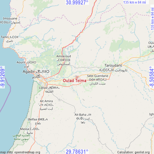
Oulad Teïma GPS coordinates[2]
30° 23' 40.812" North, 9° 12' 32.292" West
| Map corner | latitude | longitude |
|---|---|---|
| Upper-left | 30.99927°, | -9.91209° |
| Center: | 30.39467°, | -9.20897° |
| Lower-right: | 29.78631°, | -8.50584° |
| Map W x H: | 134.9×134.9 km | = 83.8×83.8mi |
| max Lat: | 35.84906° ⇑90.7% North |
| Oulad Teïma: | 30.39467° |
| min Lat: | ⇓9.3% South 22.6558° |
| min Long | Oulad Teïma | max Long |
| -15.60719° | -9.20897° | -1.22855° |
| W 9.3%⇐ | ⇒90.7% E |
Elevation
Elevation of Oulad Teïma is 129 m = 423 ft, and this is 487.8 m = 1600 ft below average elevation for this country.
| Max E: |
2637 m = 8652 ft | 77.9% |
| Avg. | 616.8 m = 2024 ft | |
| Oulad Teïma | 129 m = 423 ft | |
Min E: |
1 m = 3 ft | 22.1% |
See also: Oulad Teïma elevation on elevation.city.
Geographical zone
Oulad Teïma is located in North temperate zone (between Tropic of Cancer and the Arctic Circle). Distance of this Northern Tropic circle is 773.7 km =480.8 mi to South.| Distance of | km | miles | from Oulad Teïma |
|---|---|---|---|
| North Pole | 6627.5 | 4118.1 | to North |
| Arctic Circle | 4021.6 | 2498.9 | to North |
| Tropic Cancer | 773.7 | 480.8 | to South |
| Equator | 3379.6 | 2100 | to South |


Nearby cities:
15 places around Oulad Teïma: (largest is in red/bold)
• Agadir
37.4 km =23.2 mi,  274°
274°
• Amalou
49.6 km =30.8 mi,  117°
117°
• Aourir
42.3 km =26.3 mi,  284°
284°
• Argana
44 km =27.3 mi,  11°
11°
• Assads
38.2 km =23.7 mi, 118°
• Bigoudine
36.6 km =22.7 mi,  359°
359°
• Dakhla
33.3 km =20.7 mi, 273°
• Inezgane
31.7 km =19.7 mi,  262°
262°
• Tabia
51.2 km =31.8 mi,  141°
141°
• Tadrart
48.6 km =30.2 mi,  330°
330°
• Taghazout
50.9 km =31.6 mi,  288°
288°
• Taroudant
32.9 km =20.4 mi,  75°
75°
• Tazemmourt
36.5 km =22.7 mi,  87°
87°
• Timezgadiouine
56.6 km =35.2 mi,  16°
16°
• Tiout
49.2 km =30.6 mi, 90°
Sources, notices
• [Note1] Compared only with cities in Morocco existing in our database
• [Src1] Map data: © OpenStreetMap contributors (CC-BY-SA)
• [Src2] Other city data from geonames.org with taken over terms of usage.
• [Src3] Geographical zone / Annual Mean Temperature by Robert A. Rohde @ Wikipedia
