Aourir geodata
Aourir (Souss-Massa) is a seat of a third-order administrative division; located in Morocco in Africa/Casablanca (GMT+1) time zone. In our database, there are 108 cities with bigger population. Compared to other cities in Morocco, 88.8% of cities are located further ↑North; 94.2% of cities are located further →East and 79.1% of cities have higher elevation than Aourir. Note1


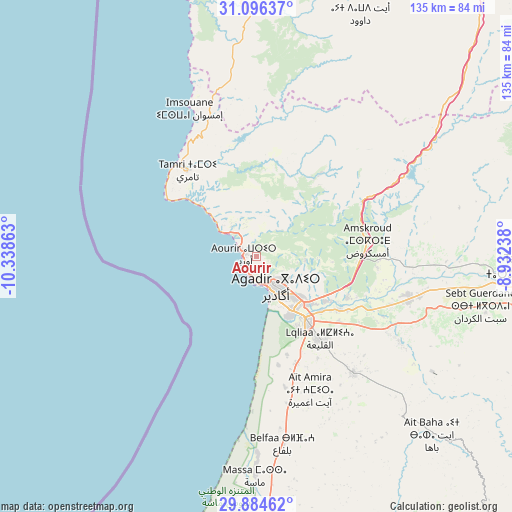
Aourir GPS coordinates[2]
30° 29' 32.568" North, 9° 38' 7.8" West
| Map corner | latitude | longitude |
|---|---|---|
| Upper-left | 31.09637°, | -10.33863° |
| Center: | 30.49238°, | -9.6355° |
| Lower-right: | 29.88462°, | -8.93238° |
| Map W x H: | 134.7×134.7 km | = 83.7×83.7mi |
| max Lat: | 35.84906° ⇑88.8% North |
| Aourir: | 30.49238° |
| min Lat: | ⇓11.2% South 22.6558° |
| min Long | Aourir | max Long |
| -15.60719° | -9.6355° | -1.22855° |
| W 5.8%⇐ | ⇒94.2% E |
Elevation
Elevation of Aourir is 121 m = 397 ft, and this is 495.8 m = 1627 ft below average elevation for this country.
| Max E: |
2637 m = 8652 ft | 79.1% |
| Avg. | 616.8 m = 2024 ft | |
| Aourir | 121 m = 397 ft | |
Min E: |
1 m = 3 ft | 20.9% |
See also: Morocco elevation on elevation.city.
Geographical zone
Aourir is located in North temperate zone (between Tropic of Cancer and the Arctic Circle). Distance of this Northern Tropic circle is 784.5 km =487.5 mi to South.| Distance of | km | miles | from Aourir |
|---|---|---|---|
| North Pole | 6616.6 | 4111.4 | to North |
| Arctic Circle | 4010.7 | 2492.1 | to North |
| Tropic Cancer | 784.5 | 487.5 | to South |
| Equator | 3390.4 | 2106.7 | to South |


Nearby cities:
15 places around Aourir: (largest is in red/bold)
• Agadir
8.8 km =5.5 mi,  155°
155°
• Argana
59 km =36.7 mi,  56°
56°
• Assads
79.9 km =49.6 mi,  111°
111°
• Bigoudine
48.1 km =29.9 mi, 57°
• Dakhla
11.9 km =7.4 mi,  139°
139°
• Inezgane
18 km =11.2 mi,  148°
148°
• Oulad Teïma
42.3 km =26.3 mi,  104°
104°
• Smimou
80.1 km =49.8 mi,  355°
355°
• Tadrart
35.6 km =22.1 mi,  28°
28°
• Taghazout
9.1 km =5.7 mi,  307°
307°
• Tamanar
56.7 km =35.2 mi, 355°
• Tamri
29.3 km =18.2 mi,  320°
320°
• Taroudant
72.7 km =45.2 mi,  91°
91°
• Tazemmourt
77.9 km =48.4 mi, 96°
• Timezgadiouine
71.2 km =44.2 mi,  52°
52°
Sources, notices
• [Note1] Compared only with cities in Morocco existing in our database
• [Src1] Map data: © OpenStreetMap contributors (CC-BY-SA)
• [Src2] Other city data from geonames.org with taken over terms of usage.
• [Src3] Geographical zone / Annual Mean Temperature by Robert A. Rohde @ Wikipedia
