Argana geodata
Argana (Souss-Massa) is a seat of a third-order administrative division; located in Morocco in Africa/Casablanca (GMT+1) time zone. In our database, there are 108 cities with bigger population. Compared to other cities in Morocco, 84.5% of cities are located further ↑North; 89.5% of cities are located further →East and 63.2% of cities have lower elevation than Argana. Note1


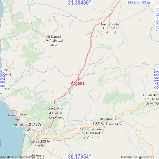
Argana GPS coordinates[2]
30° 46' 57" North, 9° 7' 10.848" West
| Map corner | latitude | longitude |
|---|---|---|
| Upper-left | 31.38466°, | -9.8228° |
| Center: | 30.7825°, | -9.11968° |
| Lower-right: | 30.17654°, | -8.41655° |
| Map W x H: | 134.3×134.3 km | = 83.5×83.5mi |
| max Lat: | 35.84906° ⇑84.5% North |
| Argana: | 30.7825° |
| min Lat: | ⇓15.5% South 22.6558° |
| min Long | Argana | max Long |
| -15.60719° | -9.11968° | -1.22855° |
| W 10.5%⇐ | ⇒89.5% E |
Elevation
Elevation of Argana is 768 m = 2520 ft, and this is 151.2 m = 496 ft above average elevation for this country.
| Max E: |
2637 m = 8652 ft | 36.8% |
| Argana | 768 m 2520 ft | |
| Avg. | 616.8 m = 2024 ft | |
Min E: |
1 m = 3 ft | 63.2% |
See also: Morocco elevation on elevation.city.
Geographical zone
Argana is located in North temperate zone (between Tropic of Cancer and the Arctic Circle). Distance of this Northern Tropic circle is 816.8 km =507.5 mi to South.| Distance of | km | miles | from Argana |
|---|---|---|---|
| North Pole | 6584.4 | 4091.4 | to North |
| Arctic Circle | 3978.5 | 2472.1 | to North |
| Tropic Cancer | 816.8 | 507.5 | to South |
| Equator | 3422.7 | 2126.8 | to South |


Nearby cities:
15 places around Argana: (largest is in red/bold)
• Agadir
61 km =37.9 mi,  228°
228°
• Aourir
59 km =36.7 mi,  236°
236°
• Arazane
58.1 km =36.1 mi,  122°
122°
• Bigoudine
10.9 km =6.8 mi, 233°
• Bouabout
54 km =33.6 mi,  354°
354°
• Dakhla
58.7 km =36.5 mi, 225°
• Inezgane
62 km =38.5 mi,  220°
220°
• Oulad Teïma
44 km =27.3 mi,  191°
191°
• Tadrart
32.5 km =20.2 mi,  268°
268°
• Tamanar
58.5 km =36.4 mi,  294°
294°
• Taouloukoult
49 km =30.4 mi,  4°
4°
• Taroudant
41.8 km =26 mi,  146°
146°
• Tazemmourt
50 km =31.1 mi, 146°
• Timezgadiouine
13.3 km =8.3 mi,  32°
32°
• Tiout
59.7 km =37.1 mi,  137°
137°
Sources, notices
• [Note1] Compared only with cities in Morocco existing in our database
• [Src1] Map data: © OpenStreetMap contributors (CC-BY-SA)
• [Src2] Other city data from geonames.org with taken over terms of usage.
• [Src3] Geographical zone / Annual Mean Temperature by Robert A. Rohde @ Wikipedia
