Skoura geodata
Skoura (Drâa-Tafilalet) is a seat of a third-order administrative division; located in Morocco in Africa/Casablanca (GMT+1) time zone. In our database, there are 108 cities with bigger population. Compared to other cities in Morocco, 81.8% of cities are located further ↑North; 58.1% of cities are located further →East and 86.4% of cities have lower elevation than Skoura. Note1


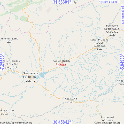
Skoura GPS coordinates[2]
31° 3' 45.432" North, 6° 33' 9" West
| Map corner | latitude | longitude |
|---|---|---|
| Upper-left | 31.66301°, | -7.25563° |
| Center: | 31.06262°, | -6.5525° |
| Lower-right: | 30.45842°, | -5.84938° |
| Map W x H: | 133.9×133.9 km | = 83.2×83.2mi |
| max Lat: | 35.84906° ⇑81.8% North |
| Skoura: | 31.06262° |
| min Lat: | ⇓18.2% South 22.6558° |
| min Long | Skoura | max Long |
| -15.60719° | -6.5525° | -1.22855° |
| W 41.9%⇐ | ⇒58.1% E |
Elevation
Elevation of Skoura is 1226 m = 4022 ft, and this is 609.2 m = 1999 ft above average elevation for this country.
| Max E: |
2637 m = 8652 ft | 13.6% |
| Skoura | 1226 m 4022 ft | |
| Avg. | 616.8 m = 2024 ft | |
Min E: |
1 m = 3 ft | 86.4% |
See also: Morocco elevation on elevation.city.
Geographical zone
Skoura is located in North temperate zone (between Tropic of Cancer and the Arctic Circle). Distance of this Northern Tropic circle is 847.9 km =526.9 mi to South.| Distance of | km | miles | from Skoura |
|---|---|---|---|
| North Pole | 6553.2 | 4072 | to North |
| Arctic Circle | 3947.3 | 2452.7 | to North |
| Tropic Cancer | 847.9 | 526.9 | to South |
| Equator | 3453.8 | 2146.1 | to South |


Nearby cities:
15 places around Skoura: (largest is in red/bold)
• Abadou
92.3 km =57.4 mi,  308°
308°
• Agdz
42.3 km =26.3 mi,  166°
166°
• Amerzgane
62.7 km =39 mi,  268°
268°
• Azilal
100 km =62.1 mi,  358°
358°
• Demnate
86.2 km =53.6 mi,  330°
330°
• Ifrane
73.7 km =45.8 mi,  15°
15°
• Imider
80 km =49.7 mi,  64°
64°
• Kelaat Mgouna
44.8 km =27.8 mi, 62°
• Ouaoula
91.7 km =57 mi,  348°
348°
• Ouarzazat
36.2 km =22.5 mi,  243°
243°
• Tabant
67 km =41.6 mi,  11°
11°
• Taznakht
82.2 km =51.1 mi,  229°
229°
• Telouet
69.9 km =43.4 mi,  291°
291°
• Tifni
72.9 km =45.3 mi, 329°
• Zerkten
90.4 km =56.2 mi,  298°
298°
Sources, notices
• [Note1] Compared only with cities in Morocco existing in our database
• [Src1] Map data: © OpenStreetMap contributors (CC-BY-SA)
• [Src2] Other city data from geonames.org with taken over terms of usage.
• [Src3] Geographical zone / Annual Mean Temperature by Robert A. Rohde @ Wikipedia
