Talmest geodata
Talmest (Marrakesh-Safi) is a seat of a third-order administrative division; located in Morocco in Africa/Casablanca (GMT+1) time zone. In our database, there are 108 cities with bigger population. Compared to other cities in Morocco, 68.2% of cities are located further ↑North; 91.9% of cities are located further →East and 73.6% of cities have higher elevation than Talmest. Note1


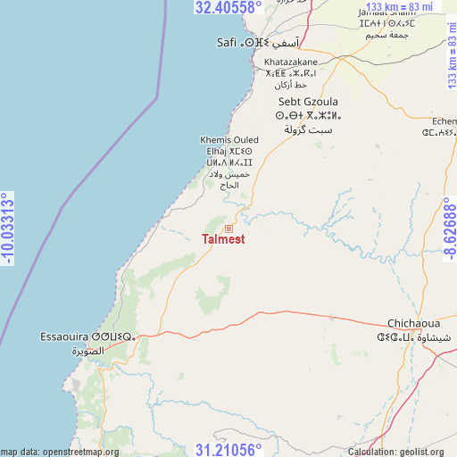
Talmest GPS coordinates[2]
31° 48' 36" North, 9° 19' 48" West
| Map corner | latitude | longitude |
|---|---|---|
| Upper-left | 32.40558°, | -10.03313° |
| Center: | 31.81°, | -9.33° |
| Lower-right: | 31.21056°, | -8.62688° |
| Map W x H: | 132.9×132.9 km | = 82.6×82.6mi |
| max Lat: | 35.84906° ⇑68.2% North |
| Talmest: | 31.81° |
| min Lat: | ⇓31.8% South 22.6558° |
| min Long | Talmest | max Long |
| -15.60719° | -9.33° | -1.22855° |
| W 8.1%⇐ | ⇒91.9% E |
Elevation
Elevation of Talmest is 182 m = 597 ft, and this is 434.8 m = 1427 ft below average elevation for this country.
| Max E: |
2637 m = 8652 ft | 73.6% |
| Avg. | 616.8 m = 2024 ft | |
| Talmest | 182 m = 597 ft | |
Min E: |
1 m = 3 ft | 26.4% |
See also: Morocco elevation on elevation.city.
Geographical zone
Talmest is located in North temperate zone (between Tropic of Cancer and the Arctic Circle). Distance of this Northern Tropic circle is 931 km =578.5 mi to South.| Distance of | km | miles | from Talmest |
|---|---|---|---|
| North Pole | 6470.1 | 4020.3 | to North |
| Arctic Circle | 3864.2 | 2401.1 | to North |
| Tropic Cancer | 931 | 578.5 | to South |
| Equator | 3536.9 | 2197.7 | to South |


Nearby cities:
15 places around Talmest: (largest is in red/bold)
• Adassil
111.5 km =69.3 mi,  134°
134°
• Argana
116 km =72.1 mi,  170°
170°
• Bigoudine
121.3 km =75.4 mi, 174°
• Bouabout
62.2 km =38.6 mi, 166°
• Chichaoua
61.3 km =38.1 mi,  118°
118°
• Essaouira
53.2 km =33.1 mi,  231°
231°
• Oualidia
106.5 km =66.2 mi,  15°
15°
• Safi
55.1 km =34.2 mi,  9°
9°
• Smimou
75.7 km =47 mi,  208°
208°
• Tadrart
115.8 km =72 mi,  186°
186°
• Tamanar
95.8 km =59.5 mi,  200°
200°
• Taouloukoult
69.5 km =43.2 mi,  160°
160°
• Timezgadiouine
106.5 km =66.2 mi, 165°
• Tizguine
115.8 km =72 mi, 123°
• Youssoufia
89.7 km =55.7 mi,  57°
57°
Sources, notices
• [Note1] Compared only with cities in Morocco existing in our database
• [Src1] Map data: © OpenStreetMap contributors (CC-BY-SA)
• [Src2] Other city data from geonames.org with taken over terms of usage.
• [Src3] Geographical zone / Annual Mean Temperature by Robert A. Rohde @ Wikipedia
