Safi geodata
Safi (Marrakesh-Safi) is a seat of a second-order administrative division; located in Morocco in Africa/Casablanca (GMT+1) time zone. With population of 288,163 people, there are 13 cities with bigger population in this country. Compared to other cities in Morocco, 60.9% of cities are located further ↑North; 91.5% of cities are located further →East and 85.3% of cities have higher elevation than Safi. Note1


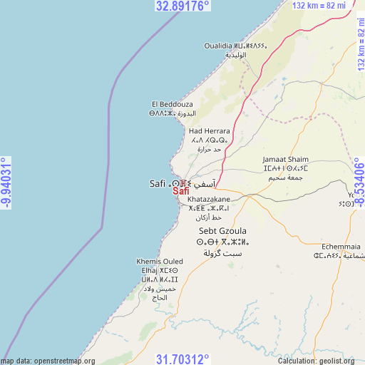
Safi GPS coordinates[2]
32° 17' 57.804" North, 9° 14' 13.848" West
| Map corner | latitude | longitude |
|---|---|---|
| Upper-left | 32.89176°, | -9.94031° |
| Center: | 32.29939°, | -9.23718° |
| Lower-right: | 31.70312°, | -8.53406° |
| Map W x H: | 132.2×132.2 km | = 82.1×82.1mi |
| max Lat: | 35.84906° ⇑60.9% North |
| Safi: | 32.29939° |
| min Lat: | ⇓39.1% South 22.6558° |
| min Long | Safi | max Long |
| -15.60719° | -9.23718° | -1.22855° |
| W 8.5%⇐ | ⇒91.5% E |
Elevation
Elevation of Safi is 45 m = 148 ft, and this is 571.8 m = 1876 ft below average elevation for this country.
| Max E: |
2637 m = 8652 ft | 85.3% |
| Avg. | 616.8 m = 2024 ft | |
| Safi | 45 m = 148 ft | |
Min E: |
1 m = 3 ft | 14.7% |
See also: Safi elevation on elevation.city.
Geographical zone
Safi is located in North temperate zone (between Tropic of Cancer and the Arctic Circle). Distance of this Northern Tropic circle is 985.4 km =612.3 mi to South.| Distance of | km | miles | from Safi |
|---|---|---|---|
| North Pole | 6415.7 | 3986.5 | to North |
| Arctic Circle | 3809.8 | 2367.3 | to North |
| Tropic Cancer | 985.4 | 612.3 | to South |
| Equator | 3591.4 | 2231.6 | to South |


Nearby cities:
15 places around Safi: (largest is in red/bold)
• Bouabout
115.1 km =71.5 mi,  177°
177°
• Boulaouane
127 km =78.9 mi,  60°
60°
• Chichaoua
95.2 km =59.2 mi,  151°
151°
• El Jadid
126.4 km =78.5 mi,  32°
32°
• Essaouira
100.9 km =62.7 mi,  209°
209°
• Moulay Abdallah
116.8 km =72.6 mi, 31°
• Oualidia
52 km =32.3 mi,  21°
21°
• Oulad Frej
119.7 km =74.4 mi,  52°
52°
• Sidi Bennour
85.5 km =53.1 mi, 62°
• Sidi Bou Othmane
129.8 km =80.7 mi,  109°
109°
• Sidi Smai’il
89.7 km =55.7 mi, 49°
• Smimou
129.1 km =80.2 mi,  200°
200°
• Talmest
55.1 km =34.2 mi,  189°
189°
• Taouloukoult
120.7 km =75 mi,  172°
172°
• Youssoufia
66.8 km =41.5 mi,  95°
95°
Sources, notices
• [Note1] Compared only with cities in Morocco existing in our database
• [Src1] Map data: © OpenStreetMap contributors (CC-BY-SA)
• [Src2] Other city data from geonames.org with taken over terms of usage.
• [Src3] Geographical zone / Annual Mean Temperature by Robert A. Rohde @ Wikipedia
