Chichaoua geodata
Chichaoua (Marrakesh-Safi) is a seat of a third-order administrative division; located in Morocco in Africa/Casablanca (GMT+1) time zone. In our database, there are 108 cities with bigger population. Compared to other cities in Morocco, 72.1% of cities are located further ↑North; 85.7% of cities are located further →East and 58.9% of cities have higher elevation than Chichaoua. Note1


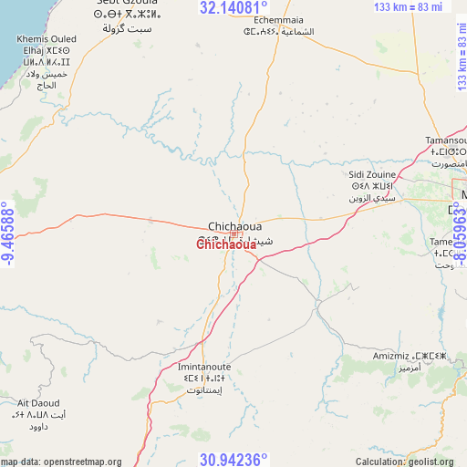
Chichaoua GPS coordinates[2]
31° 32' 36.636" North, 8° 45' 45.9" West
| Map corner | latitude | longitude |
|---|---|---|
| Upper-left | 32.14081°, | -9.46588° |
| Center: | 31.54351°, | -8.76275° |
| Lower-right: | 30.94236°, | -8.05963° |
| Map W x H: | 133.3×133.3 km | = 82.8×82.8mi |
| max Lat: | 35.84906° ⇑72.1% North |
| Chichaoua: | 31.54351° |
| min Lat: | ⇓27.9% South 22.6558° |
| min Long | Chichaoua | max Long |
| -15.60719° | -8.76275° | -1.22855° |
| W 14.3%⇐ | ⇒85.7% E |
Elevation
Elevation of Chichaoua is 356 m = 1168 ft, and this is 260.8 m = 856 ft below average elevation for this country.
| Max E: |
2637 m = 8652 ft | 58.9% |
| Avg. | 616.8 m = 2024 ft | |
| Chichaoua | 356 m = 1168 ft | |
Min E: |
1 m = 3 ft | 41.1% |
See also: Morocco elevation on elevation.city.
Geographical zone
Chichaoua is located in North temperate zone (between Tropic of Cancer and the Arctic Circle). Distance of this Northern Tropic circle is 901.4 km =560.1 mi to South.| Distance of | km | miles | from Chichaoua |
|---|---|---|---|
| North Pole | 6499.8 | 4038.8 | to North |
| Arctic Circle | 3893.9 | 2419.6 | to North |
| Tropic Cancer | 901.4 | 560.1 | to South |
| Equator | 3507.3 | 2179.3 | to South |


Nearby cities:
15 places around Chichaoua: (largest is in red/bold)
• Adassil
54.9 km =34.1 mi,  151°
151°
• Amizmiz
62.1 km =38.6 mi,  125°
125°
• Argana
91.2 km =56.7 mi,  201°
201°
• Azgour
62 km =38.5 mi,  136°
136°
• Bouabout
50.1 km =31.1 mi,  231°
231°
• Marrakesh
72.9 km =45.3 mi,  82°
82°
• Moulay Brahim
80.6 km =50.1 mi,  110°
110°
• Oukaïmedene
93.5 km =58.1 mi, 113°
• Sidi Abdallah Ghiat
88.1 km =54.7 mi,  91°
91°
• Sidi Bou Othmane
87.3 km =54.2 mi,  62°
62°
• Talmest
61.3 km =38.1 mi,  298°
298°
• Taouloukoult
46.7 km =29 mi,  220°
220°
• Timezgadiouine
78.1 km =48.5 mi, 200°
• Tizguine
55 km =34.2 mi, 129°
• Youssoufia
81.2 km =50.5 mi,  15°
15°
Sources, notices
• [Note1] Compared only with cities in Morocco existing in our database
• [Src1] Map data: © OpenStreetMap contributors (CC-BY-SA)
• [Src2] Other city data from geonames.org with taken over terms of usage.
• [Src3] Geographical zone / Annual Mean Temperature by Robert A. Rohde @ Wikipedia
