Tabant geodata
Tabant (Béni Mellal-Khénifra) is a seat of a third-order administrative division; located in Morocco in Africa/Casablanca (GMT+1) time zone. In our database, there are 108 cities with bigger population. Compared to other cities in Morocco, 70.2% of cities are located further ↑North; 56.2% of cities are located further →East and 98.4% of cities have lower elevation than Tabant. Note1


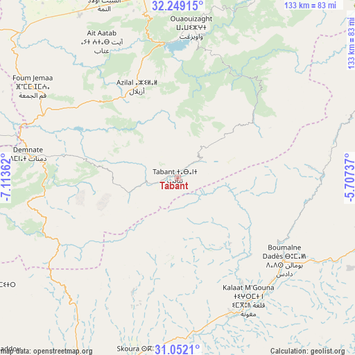
Tabant GPS coordinates[2]
31° 39' 9.18" North, 6° 24' 37.764" West
| Map corner | latitude | longitude |
|---|---|---|
| Upper-left | 32.24915°, | -7.11362° |
| Center: | 31.65255°, | -6.41049° |
| Lower-right: | 31.0521°, | -5.70737° |
| Map W x H: | 133.1×133.1 km | = 82.7×82.7mi |
| max Lat: | 35.84906° ⇑70.2% North |
| Tabant: | 31.65255° |
| min Lat: | ⇓29.8% South 22.6558° |
| min Long | Tabant | max Long |
| -15.60719° | -6.41049° | -1.22855° |
| W 43.8%⇐ | ⇒56.2% E |
Elevation
Elevation of Tabant is 1972 m = 6470 ft, and this is 1355.2 m = 4446 ft above average elevation for this country.
| Max E: |
2637 m = 8652 ft | 1.6% |
| Tabant | 1972 m 6470 ft | |
| Avg. | 616.8 m = 2024 ft | |
Min E: |
1 m = 3 ft | 98.4% |
See also: Morocco elevation on elevation.city.
Geographical zone
Tabant is located in North temperate zone (between Tropic of Cancer and the Arctic Circle). Distance of this Northern Tropic circle is 913.5 km =567.6 mi to South.| Distance of | km | miles | from Tabant |
|---|---|---|---|
| North Pole | 6487.6 | 4031.2 | to North |
| Arctic Circle | 3881.7 | 2412 | to North |
| Tropic Cancer | 913.5 | 567.6 | to South |
| Equator | 3519.4 | 2186.9 | to South |


Nearby cities:
15 places around Tabant: (largest is in red/bold)
• Anergui
64.2 km =39.9 mi,  43°
43°
• Azilal
37.6 km =23.4 mi,  336°
336°
• Demnate
57 km =35.4 mi,  279°
279°
• Ifrane
8 km =5 mi,  46°
46°
• Imider
66.2 km =41.1 mi,  117°
117°
• Isseksi
65.4 km =40.6 mi,  11°
11°
• Kelaat Mgouna
52.4 km =32.6 mi,  149°
149°
• Ouaoula
40.2 km =25 mi,  306°
306°
• Oulad Ayad
71.1 km =44.2 mi,  328°
328°
• Skoura
67 km =41.6 mi,  191°
191°
• Tabia
55.8 km =34.7 mi,  318°
318°
• Taounza
52.4 km =32.6 mi, 339°
• Tifni
50.3 km =31.3 mi,  266°
266°
• Tilmi
63.5 km =39.5 mi,  73°
73°
• Timoulilt
61.5 km =38.2 mi,  355°
355°
Sources, notices
• [Note1] Compared only with cities in Morocco existing in our database
• [Src1] Map data: © OpenStreetMap contributors (CC-BY-SA)
• [Src2] Other city data from geonames.org with taken over terms of usage.
• [Src3] Geographical zone / Annual Mean Temperature by Robert A. Rohde @ Wikipedia
