Ahfir geodata
Ahfir (Oriental) is a seat of a third-order administrative division; located in Morocco in Africa/Casablanca (GMT+1) time zone. With population of 19,611 people, there are 79 cities with bigger population in this country. Compared to other cities in Morocco, 86% of cities are located further ↓South; 97.7% of cities are located further ←West and 67.1% of cities have higher elevation than Ahfir. Note1


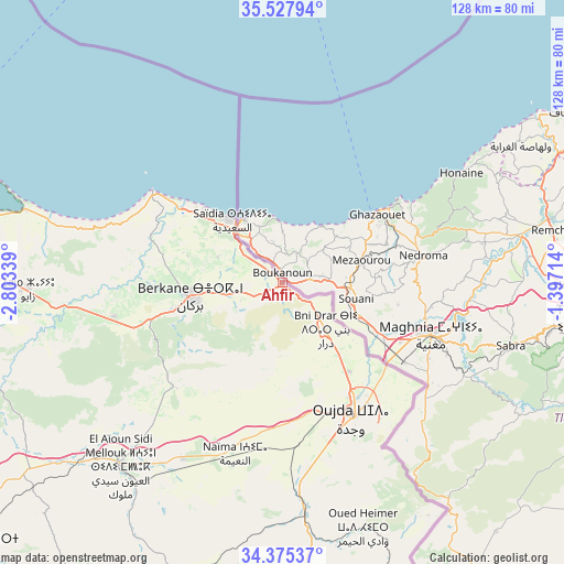
Ahfir GPS coordinates[2]
34° 57' 13.248" North, 2° 6' 0.972" West
| Map corner | latitude | longitude |
|---|---|---|
| Upper-left | 35.52794°, | -2.80339° |
| Center: | 34.95368°, | -2.10027° |
| Lower-right: | 34.37537°, | -1.39714° |
| Map W x H: | 128.2×128.2 km | = 79.7×79.7mi |
| max Lat: | 35.84906° ⇑14% North |
| Ahfir: | 34.95368° |
| min Lat: | ⇓86% South 22.6558° |
| min Long | Ahfir | max Long |
| -15.60719° | -2.10027° | -1.22855° |
| W 97.7%⇐ | ⇒2.3% E |
Elevation
Elevation of Ahfir is 252 m = 827 ft, and this is 364.8 m = 1197 ft below average elevation for this country.
| Max E: |
2637 m = 8652 ft | 67.1% |
| Avg. | 616.8 m = 2024 ft | |
| Ahfir | 252 m = 827 ft | |
Min E: |
1 m = 3 ft | 32.9% |
See also: Morocco elevation on elevation.city.
Geographical zone
Ahfir is located in North temperate zone (between Tropic of Cancer and the Arctic Circle). Distance of this Northern Tropic circle is 1280.6 km =795.7 mi to South.| Distance of | km | miles | from Ahfir |
|---|---|---|---|
| North Pole | 6120.6 | 3803.2 | to North |
| Arctic Circle | 3514.7 | 2183.9 | to North |
| Tropic Cancer | 1280.6 | 795.7 | to South |
| Equator | 3886.5 | 2415 | to South |


Nearby cities:
15 places around Ahfir: (largest is in red/bold)
• Berkane
20.4 km =12.7 mi,  259°
259°
• El Aïoun
55.4 km =34.4 mi,  221°
221°
• Guenfouda
52.5 km =32.6 mi,  174°
174°
• Hassi Berkane
71.1 km =44.2 mi, 259°
• Jerada
71.8 km =44.6 mi,  184°
184°
• Kariat Arkmane
61.3 km =38.1 mi,  286°
286°
• Madagh
22.5 km =14 mi, 286°
• Mosquée
32.9 km =20.4 mi,  240°
240°
• Oujda-Angad
35 km =21.7 mi,  149°
149°
• Rislane
38.7 km =24 mi, 238°
• Saidia
18.5 km =11.5 mi,  320°
320°
• Selouane
77.8 km =48.3 mi,  279°
279°
• Taouima
77.8 km =48.3 mi, 284°
• Tiouli
69.6 km =43.2 mi,  159°
159°
• Zaïo
57.7 km =35.9 mi,  268°
268°
Sources, notices
• [Note1] Compared only with cities in Morocco existing in our database
• [Src1] Map data: © OpenStreetMap contributors (CC-BY-SA)
• [Src2] Other city data from geonames.org with taken over terms of usage.
• [Src3] Geographical zone / Annual Mean Temperature by Robert A. Rohde @ Wikipedia
