Oujda-Angad geodata
Oujda-Angad (Oriental) is a seat of a first-order administrative division; located in Morocco in Africa/Casablanca (GMT+1) time zone. With population of 405,253 people, there are 8 cities with bigger population in this country. Compared to other cities in Morocco, 78.7% of cities are located further ↓South; 99.2% of cities are located further ←West and 54.7% of cities have lower elevation than Oujda-Angad. Note1


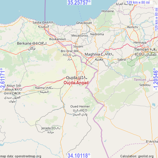
Oujda-Angad GPS coordinates[2]
34° 40' 53.004" North, 1° 54' 30.888" West
| Map corner | latitude | longitude |
|---|---|---|
| Upper-left | 35.25757°, | -2.61171° |
| Center: | 34.68139°, | -1.90858° |
| Lower-right: | 34.10118°, | -1.20546° |
| Map W x H: | 128.6×128.6 km | = 79.9×79.9mi |
| max Lat: | 35.84906° ⇑21.3% North |
| Oujda-Angad: | 34.68139° |
| min Lat: | ⇓78.7% South 22.6558° |
| min Long | Oujda-Angad | max Long |
| -15.60719° | -1.90858° | -1.22855° |
| W 99.2%⇐ | ⇒0.8% E |
Elevation
Elevation of Oujda-Angad is 549 m = 1801 ft, and this is 67.8 m = 222 ft below average elevation for this country.
| Max E: |
2637 m = 8652 ft | 45.3% |
| Avg. | 616.8 m = 2024 ft | |
| Oujda-Angad | 549 m = 1801 ft | |
Min E: |
1 m = 3 ft | 54.7% |
See also: Oujda-Angad elevation on elevation.city.
Geographical zone
Oujda-Angad is located in North temperate zone (between Tropic of Cancer and the Arctic Circle). Distance of this Northern Tropic circle is 1250.3 km =776.9 mi to South.| Distance of | km | miles | from Oujda-Angad |
|---|---|---|---|
| North Pole | 6150.9 | 3822 | to North |
| Arctic Circle | 3545 | 2202.8 | to North |
| Tropic Cancer | 1250.3 | 776.9 | to South |
| Equator | 3856.2 | 2396.1 | to South |


Nearby cities:
15 places around Oujda-Angad: (largest is in red/bold)
• Ahfir
35 km =21.7 mi,  329°
329°
• Aïn Beni Mathar
75.5 km =46.9 mi,  188°
188°
• Berkane
46 km =28.6 mi,  305°
305°
• El Aïoun
55.7 km =34.6 mi,  258°
258°
• Guenfouda
25.3 km =15.7 mi,  209°
209°
• Hassi Berkane
89.3 km =55.5 mi,  281°
281°
• Jerada
47.3 km =29.4 mi, 209°
• Kariat Arkmane
89.9 km =55.9 mi,  301°
301°
• Madagh
53.5 km =33.2 mi, 313°
• Mosquée
48.1 km =29.9 mi,  286°
286°
• Rislane
51.4 km =31.9 mi, 281°
• Saidia
53.3 km =33.1 mi, 326°
• Taourirt
95.5 km =59.3 mi,  251°
251°
• Tiouli
35.6 km =22.1 mi,  169°
169°
• Zaïo
80.7 km =50.1 mi, 291°
In other languages:
- In Spanish: Oujda
- In France: Oujda
- In German: Oujda
- In Russian: Уджда
- In Chinese: 乌季达
Sources, notices
• [Note1] Compared only with cities in Morocco existing in our database
• [Src1] Map data: © OpenStreetMap contributors (CC-BY-SA)
• [Src2] Other city data from geonames.org with taken over terms of usage.
• [Src3] Geographical zone / Annual Mean Temperature by Robert A. Rohde @ Wikipedia
