Kenitra geodata
Kenitra (Rabat-Salé-Kénitra) is a seat of a first-order administrative division; located in Morocco in Africa/Casablanca (GMT+1) time zone. With population of 366,570 people, there are 10 cities with bigger population in this country. Compared to other cities in Morocco, 69.8% of cities are located further ↓South; 59.3% of cities are located further →East and 96.1% of cities have higher elevation than Kenitra. Note1


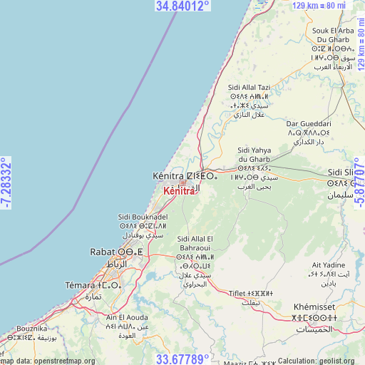
Kenitra GPS coordinates[2]
34° 15' 39.636" North, 6° 34' 48.72" West
| Map corner | latitude | longitude |
|---|---|---|
| Upper-left | 34.84012°, | -7.28332° |
| Center: | 34.26101°, | -6.5802° |
| Lower-right: | 33.67789°, | -5.87707° |
| Map W x H: | 129.2×129.2 km | = 80.3×80.3mi |
| max Lat: | 35.84906° ⇑30.2% North |
| Kenitra: | 34.26101° |
| min Lat: | ⇓69.8% South 22.6558° |
| min Long | Kenitra | max Long |
| -15.60719° | -6.5802° | -1.22855° |
| W 40.7%⇐ | ⇒59.3% E |
Elevation
Elevation of Kenitra is 13 m = 43 ft, and this is 603.8 m = 1981 ft below average elevation for this country.
| Max E: |
2637 m = 8652 ft | 96.1% |
| Avg. | 616.8 m = 2024 ft | |
| Kenitra | 13 m = 43 ft | |
Min E: |
1 m = 3 ft | 3.9% |
See also: Kenitra elevation on elevation.city.
Geographical zone
Kenitra is located in North temperate zone (between Tropic of Cancer and the Arctic Circle). Distance of this Northern Tropic circle is 1203.5 km =747.8 mi to South.| Distance of | km | miles | from Kenitra |
|---|---|---|---|
| North Pole | 6197.6 | 3851 | to North |
| Arctic Circle | 3591.7 | 2231.8 | to North |
| Tropic Cancer | 1203.5 | 747.8 | to South |
| Equator | 3809.5 | 2367.1 | to South |


Nearby cities:
15 places around Kenitra: (largest is in red/bold)
• Arbaoua
91.8 km =57 mi,  39°
39°
• Bouznika
74.8 km =46.5 mi,  225°
225°
• Had Kourt
86.5 km =53.7 mi,  62°
62°
• Khemisset
67.8 km =42.1 mi,  135°
135°
• Lalla Mimouna
80.3 km =49.9 mi, 35°
• Mechraa Bel Ksiri
67 km =41.6 mi, 58°
• Rabat
36 km =22.4 mi,  220°
220°
• Sale
30.6 km =19 mi, 220°
• Sidi Qacem
80.3 km =49.9 mi,  93°
93°
• Sidi Slimane
60.1 km =37.3 mi, 89°
• Sidi Yahia El Gharb
25.8 km =16 mi,  79°
79°
• Skhirate
61.6 km =38.3 mi, 222°
• Souq Larb’a al Gharb
71 km =44.1 mi,  48°
48°
• Temara
47.6 km =29.6 mi, 219°
• Tiflet
47.9 km =29.8 mi,  148°
148°
Sources, notices
• [Note1] Compared only with cities in Morocco existing in our database
• [Src1] Map data: © OpenStreetMap contributors (CC-BY-SA)
• [Src2] Other city data from geonames.org with taken over terms of usage.
• [Src3] Geographical zone / Annual Mean Temperature by Robert A. Rohde @ Wikipedia
