Rabat geodata
Rabat (Rabat-Salé-Kénitra) is a capital of a political entity; located in Morocco in Africa/Casablanca (GMT+1) time zone. With population of 1,655,753 people, there is 1 city with bigger population in this country. Compared to other cities in Morocco, 65.1% of cities are located further ↓South; 62.4% of cities are located further →East and 84.5% of cities have higher elevation than Rabat. Note1


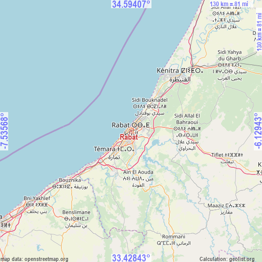
Rabat GPS coordinates[2]
34° 0' 47.7" North, 6° 49' 57.18" West
| Map corner | latitude | longitude |
|---|---|---|
| Upper-left | 34.59407°, | -7.53568° |
| Center: | 34.01325°, | -6.83255° |
| Lower-right: | 33.42843°, | -6.12943° |
| Map W x H: | 129.6×129.6 km | = 80.5×80.5mi |
| max Lat: | 35.84906° ⇑34.9% North |
| Rabat: | 34.01325° |
| min Lat: | ⇓65.1% South 22.6558° |
| min Long | Rabat | max Long |
| -15.60719° | -6.83255° | -1.22855° |
| W 37.6%⇐ | ⇒62.4% E |
Elevation
Elevation of Rabat is 46 m = 151 ft, and this is 570.8 m = 1873 ft below average elevation for this country.
| Max E: |
2637 m = 8652 ft | 84.5% |
| Avg. | 616.8 m = 2024 ft | |
| Rabat | 46 m = 151 ft | |
Min E: |
1 m = 3 ft | 15.5% |
See also: Rabat elevation on elevation.city.
Geographical zone
Rabat is located in North temperate zone (between Tropic of Cancer and the Arctic Circle). Distance of this Northern Tropic circle is 1176 km =730.7 mi to South.| Distance of | km | miles | from Rabat |
|---|---|---|---|
| North Pole | 6225.1 | 3868.1 | to North |
| Arctic Circle | 3619.3 | 2248.9 | to North |
| Tropic Cancer | 1176 | 730.7 | to South |
| Equator | 3781.9 | 2350 | to South |


Nearby cities:
15 places around Rabat: (largest is in red/bold)
• Bouznika
39.1 km =24.3 mi,  230°
230°
• Casablanca
86.1 km =53.5 mi,  236°
236°
• Ezzhiliga
84.1 km =52.3 mi,  160°
160°
• Kenitra
36 km =22.4 mi,  40°
40°
• Khemisset
73.8 km =45.9 mi,  106°
106°
• Mediouna
89.1 km =55.4 mi, 225°
• Mellila
75.9 km =47.2 mi,  201°
201°
• Mohammedia
62.5 km =38.8 mi, 234°
• Sale
5.4 km =3.4 mi, 35°
• Sidi Slimane
88 km =54.7 mi,  71°
71°
• Sidi Yahia El Gharb
58.5 km =36.4 mi,  56°
56°
• Skhirate
25.6 km =15.9 mi, 225°
• Temara
11.6 km =7.2 mi,  215°
215°
• Tiflet
50.3 km =31.3 mi, 105°
• Tit Mellil
78.8 km =49 mi, 230°
Sources, notices
• [Note1] Compared only with cities in Morocco existing in our database
• [Src1] Map data: © OpenStreetMap contributors (CC-BY-SA)
• [Src2] Other city data from geonames.org with taken over terms of usage.
• [Src3] Geographical zone / Annual Mean Temperature by Robert A. Rohde @ Wikipedia
