Bouznika geodata
Bouznika (Casablanca-Settat) is a seat of a third-order administrative division; located in Morocco in Africa/Casablanca (GMT+1) time zone. With population of 27,283 people, there are 73 cities with bigger population in this country. Compared to other cities in Morocco, 60.1% of cities are located further ↓South; 66.3% of cities are located further →East and 86% of cities have higher elevation than Bouznika. Note1


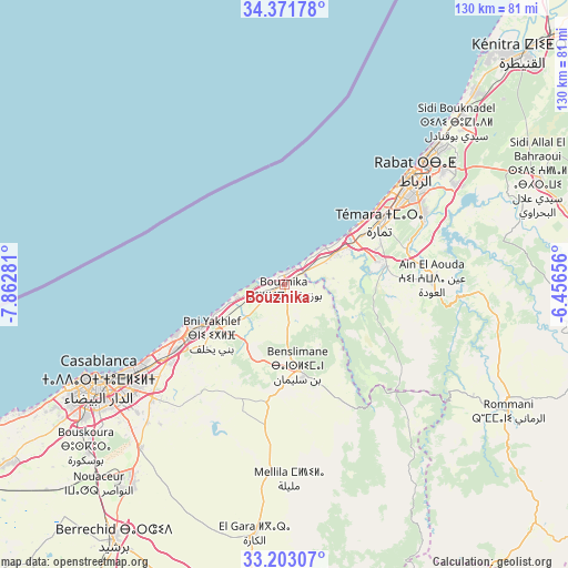
Bouznika GPS coordinates[2]
33° 47' 21.912" North, 7° 9' 34.848" West
| Map corner | latitude | longitude |
|---|---|---|
| Upper-left | 34.37178°, | -7.86281° |
| Center: | 33.78942°, | -7.15968° |
| Lower-right: | 33.20307°, | -6.45656° |
| Map W x H: | 129.9×129.9 km | = 80.7×80.7mi |
| max Lat: | 35.84906° ⇑39.9% North |
| Bouznika: | 33.78942° |
| min Lat: | ⇓60.1% South 22.6558° |
| min Long | Bouznika | max Long |
| -15.60719° | -7.15968° | -1.22855° |
| W 33.7%⇐ | ⇒66.3% E |
Elevation
Elevation of Bouznika is 43 m = 141 ft, and this is 573.8 m = 1883 ft below average elevation for this country.
| Max E: |
2637 m = 8652 ft | 86% |
| Avg. | 616.8 m = 2024 ft | |
| Bouznika | 43 m = 141 ft | |
Min E: |
1 m = 3 ft | 14% |
See also: Morocco elevation on elevation.city.
Geographical zone
Bouznika is located in North temperate zone (between Tropic of Cancer and the Arctic Circle). Distance of this Northern Tropic circle is 1151.1 km =715.3 mi to South.| Distance of | km | miles | from Bouznika |
|---|---|---|---|
| North Pole | 6250 | 3883.6 | to North |
| Arctic Circle | 3644.1 | 2264.3 | to North |
| Tropic Cancer | 1151.1 | 715.3 | to South |
| Equator | 3757 | 2334.5 | to South |


Nearby cities:
15 places around Bouznika: (largest is in red/bold)
• Berrechid
70.5 km =43.8 mi,  214°
214°
• Bouskoura
59.2 km =36.8 mi,  230°
230°
• Casablanca
47.4 km =29.5 mi,  241°
241°
• Dar Bouazza
68 km =42.3 mi, 243°
• Kenitra
74.8 km =46.5 mi,  45°
45°
• Mediouna
50.2 km =31.2 mi,  221°
221°
• Mellila
45.6 km =28.3 mi,  177°
177°
• Mohammedia
23.6 km =14.7 mi, 240°
• Rabat
39.1 km =24.3 mi, 50°
• Riah
73.7 km =45.8 mi,  195°
195°
• Sale
44.4 km =27.6 mi, 48°
• Skhirate
13.8 km =8.6 mi,  59°
59°
• Temara
28 km =17.4 mi, 56°
• Tit Mellil
39.7 km =24.7 mi, 229°
• Zawyat an Nwaçer
62.3 km =38.7 mi, 223°
Sources, notices
• [Note1] Compared only with cities in Morocco existing in our database
• [Src1] Map data: © OpenStreetMap contributors (CC-BY-SA)
• [Src2] Other city data from geonames.org with taken over terms of usage.
• [Src3] Geographical zone / Annual Mean Temperature by Robert A. Rohde @ Wikipedia
