Khemisset geodata
Khemisset (Rabat-Salé-Kénitra) is a seat of a third-order administrative division; located in Morocco in Africa/Casablanca (GMT+1) time zone. With population of 106,991 people, there are 24 cities with bigger population in this country. Compared to other cities in Morocco, 60.5% of cities are located further ↓South; 52.3% of cities are located further →East and 51.2% of cities have higher elevation than Khemisset. Note1


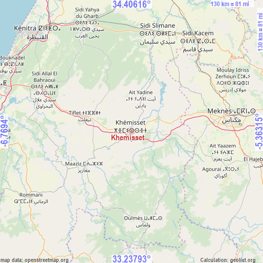
Khemisset GPS coordinates[2]
33° 49' 26.544" North, 6° 3' 58.572" West
| Map corner | latitude | longitude |
|---|---|---|
| Upper-left | 34.40616°, | -6.7694° |
| Center: | 33.82404°, | -6.06627° |
| Lower-right: | 33.23793°, | -5.36315° |
| Map W x H: | 129.9×129.9 km | = 80.7×80.7mi |
| max Lat: | 35.84906° ⇑39.5% North |
| Khemisset: | 33.82404° |
| min Lat: | ⇓60.5% South 22.6558° |
| min Long | Khemisset | max Long |
| -15.60719° | -6.06627° | -1.22855° |
| W 47.7%⇐ | ⇒52.3% E |
Elevation
Elevation of Khemisset is 451 m = 1480 ft, and this is 165.8 m = 544 ft below average elevation for this country.
| Max E: |
2637 m = 8652 ft | 51.2% |
| Avg. | 616.8 m = 2024 ft | |
| Khemisset | 451 m = 1480 ft | |
Min E: |
1 m = 3 ft | 48.8% |
See also: Khemisset elevation on elevation.city.
Geographical zone
Khemisset is located in North temperate zone (between Tropic of Cancer and the Arctic Circle). Distance of this Northern Tropic circle is 1155 km =717.7 mi to South.| Distance of | km | miles | from Khemisset |
|---|---|---|---|
| North Pole | 6246.2 | 3881.2 | to North |
| Arctic Circle | 3640.3 | 2262 | to North |
| Tropic Cancer | 1155 | 717.7 | to South |
| Equator | 3760.9 | 2336.9 | to South |


Nearby cities:
15 places around Khemisset: (largest is in red/bold)
• Aguelmous
76.5 km =47.5 mi,  164°
164°
• El Hajeb
66 km =41 mi,  103°
103°
• Ezzhiliga
72.4 km =45 mi,  216°
216°
• Kenitra
67.8 km =42.1 mi,  315°
315°
• Mechraa Bel Ksiri
84 km =52.2 mi,  6°
6°
• Meknès
48.5 km =30.1 mi,  80°
80°
• Moulay Yacoub
86.7 km =53.9 mi,  70°
70°
• Oulmes
44.7 km =27.8 mi,  172°
172°
• Rabat
73.8 km =45.9 mi,  286°
286°
• Sale
72.2 km =44.9 mi, 290°
• Sidi Qacem
55.2 km =34.3 mi,  36°
36°
• Sidi Slimane
50.7 km =31.5 mi, 14°
• Sidi Yahia El Gharb
57.8 km =35.9 mi,  337°
337°
• Temara
78.4 km =48.7 mi,  278°
278°
• Tiflet
23.5 km =14.6 mi, 289°
Sources, notices
• [Note1] Compared only with cities in Morocco existing in our database
• [Src1] Map data: © OpenStreetMap contributors (CC-BY-SA)
• [Src2] Other city data from geonames.org with taken over terms of usage.
• [Src3] Geographical zone / Annual Mean Temperature by Robert A. Rohde @ Wikipedia
