Arbaoua geodata
Arbaoua (Rabat-Salé-Kénitra) is a seat of a third-order administrative division; located in Morocco in Africa/Casablanca (GMT+1) time zone. In our database, there are 108 cities with bigger population. Compared to other cities in Morocco, 83.3% of cities are located further ↓South; 50.4% of cities are located further ←West and 76.7% of cities have higher elevation than Arbaoua. Note1


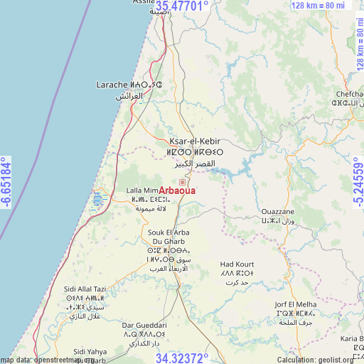
Arbaoua GPS coordinates[2]
34° 54' 8.604" North, 5° 56' 55.356" West
| Map corner | latitude | longitude |
|---|---|---|
| Upper-left | 35.47701°, | -6.65184° |
| Center: | 34.90239°, | -5.94871° |
| Lower-right: | 34.32372°, | -5.24559° |
| Map W x H: | 128.2×128.2 km | = 79.7×79.7mi |
| max Lat: | 35.84906° ⇑16.7% North |
| Arbaoua: | 34.90239° |
| min Lat: | ⇓83.3% South 22.6558° |
| min Long | Arbaoua | max Long |
| -15.60719° | -5.94871° | -1.22855° |
| W 50.4%⇐ | ⇒49.6% E |
Elevation
Elevation of Arbaoua is 143 m = 469 ft, and this is 473.8 m = 1554 ft below average elevation for this country.
| Max E: |
2637 m = 8652 ft | 76.7% |
| Avg. | 616.8 m = 2024 ft | |
| Arbaoua | 143 m = 469 ft | |
Min E: |
1 m = 3 ft | 23.3% |
See also: Morocco elevation on elevation.city.
Geographical zone
Arbaoua is located in North temperate zone (between Tropic of Cancer and the Arctic Circle). Distance of this Northern Tropic circle is 1274.9 km =792.2 mi to South.| Distance of | km | miles | from Arbaoua |
|---|---|---|---|
| North Pole | 6126.3 | 3806.7 | to North |
| Arctic Circle | 3520.4 | 2187.5 | to North |
| Tropic Cancer | 1274.9 | 792.2 | to South |
| Equator | 3880.8 | 2411.4 | to South |


Nearby cities:
15 places around Arbaoua: (largest is in red/bold)
• Asilah
63.1 km =39.2 mi,  352°
352°
• Brikcha
35 km =21.7 mi,  78°
78°
• Derdara
64.3 km =40 mi,  68°
68°
• Fifi
64.1 km =39.8 mi,  85°
85°
• Had Kourt
37.1 km =23.1 mi,  149°
149°
• Ksar El Kebir
11.6 km =7.2 mi,  20°
20°
• Lalla Mimouna
12.4 km =7.7 mi,  239°
239°
• Larache
37.4 km =23.2 mi,  329°
329°
• Mechraa Bel Ksiri
36.5 km =22.7 mi,  181°
181°
• Ouezzane
35.8 km =22.2 mi,  109°
109°
• Sidi Bousber
65.6 km =40.8 mi,  125°
125°
• Sidi Redouane
51.8 km =32.2 mi,  117°
117°
• Souq Larb’a al Gharb
24.5 km =15.2 mi,  191°
191°
• Teroual
66.7 km =41.4 mi, 112°
• Zoumi
56.2 km =34.9 mi,  101°
101°
Sources, notices
• [Note1] Compared only with cities in Morocco existing in our database
• [Src1] Map data: © OpenStreetMap contributors (CC-BY-SA)
• [Src2] Other city data from geonames.org with taken over terms of usage.
• [Src3] Geographical zone / Annual Mean Temperature by Robert A. Rohde @ Wikipedia
