Mechraa Bel Ksiri geodata
Mechraa Bel Ksiri (Rabat-Salé-Kénitra) is a seat of a third-order administrative division; located in Morocco in Africa/Casablanca (GMT+1) time zone. With population of 27,802 people, there are 72 cities with bigger population in this country. Compared to other cities in Morocco, 76.4% of cities are located further ↓South; 50% of cities are located further ←West and 92.2% of cities have higher elevation than Mechraa Bel Ksiri. Note1
Administrative division(s):
- Level 1: Rabat-Salé-Kénitra
- Level 2: Sidi-Kacem
- Level 3: Mechra Bel Ksiri


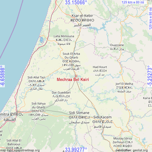
Mechraa Bel Ksiri GPS coordinates[2]
34° 34' 25.428" North, 5° 57' 21.06" West
| Map corner | latitude | longitude |
|---|---|---|
| Upper-left | 35.15066°, | -6.65898° |
| Center: | 34.57373°, | -5.95585° |
| Lower-right: | 33.99277°, | -5.25273° |
| Map W x H: | 128.7×128.7 km | = 80×80mi |
| max Lat: | 35.84906° ⇑23.6% North |
| Mechraa Bel Ksiri: | 34.57373° |
| min Lat: | ⇓76.4% South 22.6558° |
| min Long | Mechraa Bel Ksi | max Long |
| -15.60719° | -5.95585° | -1.22855° |
| W 50%⇐ | ⇒50% E |
Elevation
Elevation of Mechraa Bel Ksiri is 20 m = 66 ft, and this is 596.8 m = 1958 ft below average elevation for this country.
| Max E: |
2637 m = 8652 ft | 92.2% |
| Avg. | 616.8 m = 2024 ft | |
| Mechraa Bel Ksiri | 20 m = 66 ft | |
Min E: |
1 m = 3 ft | 7.8% |
See also: Morocco elevation on elevation.city.
Geographical zone
Mechraa Bel Ksiri is located in North temperate zone (between Tropic of Cancer and the Arctic Circle). Distance of this Northern Tropic circle is 1238.3 km =769.4 mi to South.| Distance of | km | miles | from Mechraa Bel Ksiri |
|---|---|---|---|
| North Pole | 6162.8 | 3829.4 | to North |
| Arctic Circle | 3556.9 | 2210.2 | to North |
| Tropic Cancer | 1238.3 | 769.4 | to South |
| Equator | 3844.2 | 2388.7 | to South |


Nearby cities:
15 places around Mechraa Bel Ksiri: (largest is in red/bold)
• Arbaoua
36.5 km =22.7 mi,  1°
1°
• Brikcha
56 km =34.8 mi,  38°
38°
• Ghouazi
60.8 km =37.8 mi,  100°
100°
• Had Kourt
20.3 km =12.6 mi,  76°
76°
• Ksar El Kebir
47.7 km =29.6 mi,  5°
5°
• Lalla Mimouna
31.9 km =19.8 mi,  341°
341°
• Ouezzane
42.4 km =26.3 mi,  54°
54°
• Sidi Bousber
54.4 km =33.8 mi,  91°
91°
• Sidi Qacem
45.3 km =28.1 mi,  149°
149°
• Sidi Redouane
48.4 km =30.1 mi,  74°
74°
• Sidi Slimane
34.5 km =21.4 mi,  175°
175°
• Sidi Yahia El Gharb
43.7 km =27.2 mi,  226°
226°
• Souq Larb’a al Gharb
13.3 km =8.3 mi, 341°
• Teroual
63.4 km =39.4 mi, 79°
• Zoumi
61.4 km =38.2 mi, 65°
Sources, notices
• [Note1] Compared only with cities in Morocco existing in our database
• [Src1] Map data: © OpenStreetMap contributors (CC-BY-SA)
• [Src2] Other city data from geonames.org with taken over terms of usage.
• [Src3] Geographical zone / Annual Mean Temperature by Robert A. Rohde @ Wikipedia
