Isseksi geodata
Isseksi (Béni Mellal-Khénifra) is a seat of a third-order administrative division; located in Morocco in Africa/Casablanca (GMT+1) time zone. In our database, there are 108 cities with bigger population. Compared to other cities in Morocco, 62.4% of cities are located further ↑North; 54.3% of cities are located further →East and 90.3% of cities have lower elevation than Isseksi. Note1


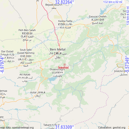
Isseksi GPS coordinates[2]
32° 13' 47.316" North, 6° 16' 35.796" West
| Map corner | latitude | longitude |
|---|---|---|
| Upper-left | 32.82264°, | -6.97974° |
| Center: | 32.22981°, | -6.27661° |
| Lower-right: | 31.63309°, | -5.57349° |
| Map W x H: | 132.3×132.3 km | = 82.2×82.2mi |
| max Lat: | 35.84906° ⇑62.4% North |
| Isseksi: | 32.22981° |
| min Lat: | ⇓37.6% South 22.6558° |
| min Long | Isseksi | max Long |
| -15.60719° | -6.27661° | -1.22855° |
| W 45.7%⇐ | ⇒54.3% E |
Elevation
Elevation of Isseksi is 1407 m = 4616 ft, and this is 790.2 m = 2593 ft above average elevation for this country.
| Max E: |
2637 m = 8652 ft | 9.7% |
| Isseksi | 1407 m 4616 ft | |
| Avg. | 616.8 m = 2024 ft | |
Min E: |
1 m = 3 ft | 90.3% |
See also: Morocco elevation on elevation.city.
Geographical zone
Isseksi is located in North temperate zone (between Tropic of Cancer and the Arctic Circle). Distance of this Northern Tropic circle is 977.7 km =607.5 mi to South.| Distance of | km | miles | from Isseksi |
|---|---|---|---|
| North Pole | 6423.4 | 3991.3 | to North |
| Arctic Circle | 3817.6 | 2372.1 | to North |
| Tropic Cancer | 977.7 | 607.5 | to South |
| Equator | 3583.6 | 2226.7 | to South |


Nearby cities:
15 places around Isseksi: (largest is in red/bold)
• Al Fqih Ben Çalah
49.1 km =30.5 mi,  308°
308°
• Anergui
36.4 km =22.6 mi,  119°
119°
• Azilal
40.7 km =25.3 mi,  222°
222°
• Beni Mellal
13.8 km =8.6 mi,  330°
330°
• Dar Ould Zidouh
59.8 km =37.2 mi,  278°
278°
• El Ksiba
45.1 km =28 mi,  32°
32°
• Ifrane
59.1 km =36.7 mi,  186°
186°
• Kasba Tadla
40.9 km =25.4 mi,  1°
1°
• Ouaoula
59.9 km =37.2 mi,  228°
228°
• Oulad Ayad
49.3 km =30.6 mi,  266°
266°
• Sidi Jaber
22.3 km =13.9 mi,  322°
322°
• Tabia
54 km =33.6 mi,  245°
245°
• Taounza
34.5 km =21.4 mi,  243°
243°
• Timoulilt
18.1 km =11.2 mi,  260°
260°
• Zawyat ech Cheïkh
57.1 km =35.5 mi,  36°
36°
Sources, notices
• [Note1] Compared only with cities in Morocco existing in our database
• [Src1] Map data: © OpenStreetMap contributors (CC-BY-SA)
• [Src2] Other city data from geonames.org with taken over terms of usage.
• [Src3] Geographical zone / Annual Mean Temperature by Robert A. Rohde @ Wikipedia
